IMAGES TAKEN NEAR TO
Delta Way, NORTHAMPTON, NN2 8QB
Introduction
This page details the photographs taken nearby to Delta Way, NN2 8QB by members of the Geograph project.
The Geograph project started in 2005 with the aim of publishing, organising and preserving representative images for every square kilometre of Great Britain, Ireland and the Isle of Man.

There are currently over 7.5m images from over14,400 individuals and you can help contribute to the project by visiting https://www.geograph.org.uk
Image Map
Images are licensed for reuse under creativecommons.org/licenses/by-sa/2.0
Notes
- Clicking on the map will re-center to the selected point.
- The higher the marker number, the further away the image location is from the centre of the postcode.
Image Listing (22 Images Found)
Images are licensed for reuse under creativecommons.org/licenses/by-sa/2.0
Image
Details
Distance
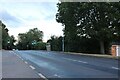
1
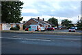
The A5199
This road joins the A508 in Kingsthorpe. The red structure is a bus shelter.
Image: © Kokai
Taken: 15 Aug 2006
0.03 miles
2
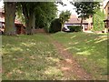
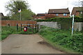
Footpath to Spring Park
This section of the footpath runs north-east from a cycleway through an outlying area of Northampton.
Image: © Kokai
Taken: 15 Aug 2006
0.06 miles
3
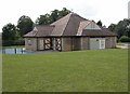
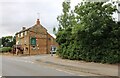
Pastures Community Centre
Situated in Spring Park.
Image: © Kokai
Taken: 15 Aug 2006
0.08 miles
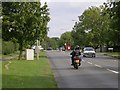
4
Welford Road, Kingsthorpe
Looking towards Larwood Close
Image: © David Howard
Taken: 2 Aug 2022
0.11 miles
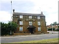
7
The Windmill pub on Welford Road, Kingsthorpe
Image: © David Howard
Taken: 2 Aug 2022
0.12 miles
8
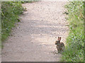
Rabbit on Cycleway
Frozen in a fairly nonchalant manner.
Image: © Kokai
Taken: 15 Aug 2006
0.13 miles
9
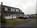
Grasscroft
1970s houses in Kingsthorpe.
Image: © Burgess Von Thunen
Taken: 22 Jan 2015
0.13 miles