IMAGES TAKEN NEAR TO
Harborough Road, NORTHAMPTON, NN2 8DL
Introduction
This page details the photographs taken nearby to Harborough Road, NN2 8DL by members of the Geograph project.
The Geograph project started in 2005 with the aim of publishing, organising and preserving representative images for every square kilometre of Great Britain, Ireland and the Isle of Man.

There are currently over 7.5m images from over14,400 individuals and you can help contribute to the project by visiting https://www.geograph.org.uk
Image Map
Images are licensed for reuse under creativecommons.org/licenses/by-sa/2.0
Notes
- Clicking on the map will re-center to the selected point.
- The higher the marker number, the further away the image location is from the centre of the postcode.
Image Listing (29 Images Found)
Images are licensed for reuse under creativecommons.org/licenses/by-sa/2.0
Image
Details
Distance
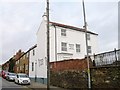
1
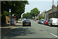
A508 Harborough Road, Northampton
Heading north out of town.
Image: © Robin Webster
Taken: 23 Jun 2019
0.06 miles
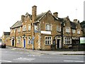
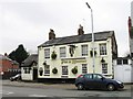
2
The Prince of Wales
At the junction of Boughton Green Road and Harborough Road.
Image: © Burgess Von Thunen
Taken: 19 May 2011
0.06 miles
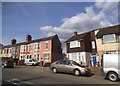
3
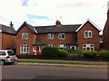
Boughton Green Road
1930s council houses in Kingsthorpe.
Image: © Burgess Von Thunen
Taken: 11 Aug 2013
0.07 miles
5
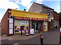
Krates
General store on Boughton Green Road.
Image: © Burgess Von Thunen
Taken: 11 Aug 2013
0.09 miles
6
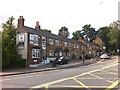
Harborough Road
Cottages in Kingsthorpe.
Image: © Burgess Von Thunen
Taken: 11 Aug 2013
0.09 miles
9
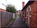
Public footpath to Ruskin Road
From Boughton Green Road.
Image: © Burgess Von Thunen
Taken: 11 Aug 2013
0.11 miles