IMAGES TAKEN NEAR TO
Westminster Walk, CORBY, NN18 9JA
Introduction
This page details the photographs taken nearby to Westminster Walk, NN18 9JA by members of the Geograph project.
The Geograph project started in 2005 with the aim of publishing, organising and preserving representative images for every square kilometre of Great Britain, Ireland and the Isle of Man.

There are currently over 7.5m images from over14,400 individuals and you can help contribute to the project by visiting https://www.geograph.org.uk
Image Map (Loading...)


Getting Data...Please wait
Leaflet Map data © OpenStreetMap
Images are licensed for reuse under creativecommons.org/licenses/by-sa/2.0
Notes
- Clicking on the map will re-center to the selected point.
- The higher the marker number, the further away the image location is from the centre of the postcode.
Image Listing (6 Images Found)
Images are licensed for reuse under creativecommons.org/licenses/by-sa/2.0
Image
Details
Distance
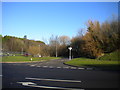
1
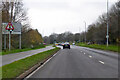
Approaching roundabout on Oakley Road (A6014)
Image: © JThomas
Taken: 27 Sep 2022
0.09 miles
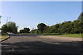
3
West end of Bankside, Oakley Vale
Off Oldland Road.
Image: © Richard Vince
Taken: 18 Jan 2020
0.13 miles
4
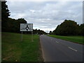
A6014 Oakley Road, Corby
Towards Kettering. Note the thoughtful road sign positioning on the left.
Image: © Robin Webster
Taken: 5 Dec 2021
0.13 miles
5
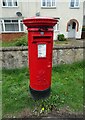
Elizabeth II postbox on Oakley Road
Postbox No. NN18 112.
Image: © JThomas
Taken: 27 Sep 2022
0.21 miles