IMAGES TAKEN NEAR TO
Grantham Walk, CORBY, NN18 9BW
Introduction
This page details the photographs taken nearby to Grantham Walk, NN18 9BW by members of the Geograph project.
The Geograph project started in 2005 with the aim of publishing, organising and preserving representative images for every square kilometre of Great Britain, Ireland and the Isle of Man.

There are currently over 7.5m images from over14,400 individuals and you can help contribute to the project by visiting https://www.geograph.org.uk
Image Map (14 Images)


Getting Data...Please wait
Leaflet Map data © OpenStreetMap
Images are licensed for reuse under creativecommons.org/licenses/by-sa/2.0
Notes
- Clicking on the map will re-center to the selected point.
- The higher the marker number, the further away the image location is from the centre of the postcode.
Image Listing (14 Images Found)
Images are licensed for reuse under creativecommons.org/licenses/by-sa/2.0
Image
Details
Distance
1
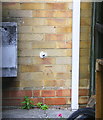
Benchmark on #1 Scarborough Walk
Ordnance Survey cut mark benchmark described on the Bench Mark Database at www.bench-marks.org.uk/bm111627
Image: © phil Richards
Taken: 12 Sep 2019
0.09 miles
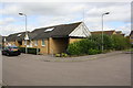
2
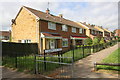
Semi-detached houses of Scarborough Walk, off Gainsborough Road
There is an OS benchmark Image on the side of the nearest house just through the wooden gate
Image: © phil Richards
Taken: 12 Sep 2019
0.09 miles
3
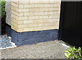
Benchmark on #2 York Road
Ordnance Survey cut mark benchmark described on the Bench Mark Database at www.bench-marks.org.uk/bm111628
Image: © phil Richards
Taken: 12 Sep 2019
0.13 miles
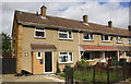
4
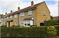
Houses of York Road off Gainsborough Road
There is an OS benchmark Image on the front corner of the nearest house, on the right hand face left of the black wooden gate (but hidden in the image behind the hedge)
Image: © phil Richards
Taken: 12 Sep 2019
0.14 miles
5
#66 Southbrook
Old maps (1971,1985) show a house #254 Lincoln Way at this location
Image: © Roger Templeman
Taken: 12 Sep 2019
0.15 miles
6
Gainsborough Road Houses
There is an OS benchmark Image on the side of the left hand house at its front corner
Image: © phil Richards
Taken: 12 Sep 2019
0.16 miles
7
Path to Kingswood Primary Academy from Southbrook
Image: © Roger Templeman
Taken: 12 Sep 2019
0.16 miles
8
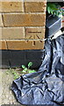
Benchmark on #426 Gainsborough Road
Ordnance Survey cut mark benchmark described on the Bench Mark Database at www.bench-marks.org.uk/bm111626
Image: © phil Richards
Taken: 12 Sep 2019
0.16 miles
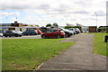
9
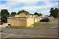
Garage block on north side of Southbrook
There is an OS benchmark Image on the rear face of the block at the near corner
Image: © phil Richards
Taken: 12 Sep 2019
0.19 miles
10
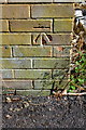
Benchmark on garage block on north side of Southbrook
Ordnance Survey cut mark benchmark described on the Bench Mark Database at www.bench-marks.org.uk/bm111629
Image: © phil Richards
Taken: 12 Sep 2019
0.19 miles