IMAGES TAKEN NEAR TO
Flinders Close, CORBY, NN18 8TW
Introduction
This page details the photographs taken nearby to Flinders Close, NN18 8TW by members of the Geograph project.
The Geograph project started in 2005 with the aim of publishing, organising and preserving representative images for every square kilometre of Great Britain, Ireland and the Isle of Man.

There are currently over 7.5m images from over14,400 individuals and you can help contribute to the project by visiting https://www.geograph.org.uk
Image Map (Loading...)


Getting Data...Please wait
Leaflet Map data © OpenStreetMap
Images are licensed for reuse under creativecommons.org/licenses/by-sa/2.0
Notes
- Clicking on the map will re-center to the selected point.
- The higher the marker number, the further away the image location is from the centre of the postcode.
Image Listing (7 Images Found)
Images are licensed for reuse under creativecommons.org/licenses/by-sa/2.0
Image
Details
Distance
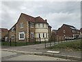
1
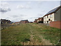
New housing at the end of Thorney Lane
Image: © Jonathan Thacker
Taken: 2 Sep 2019
0.03 miles
2
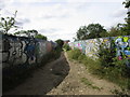
Bridge over the railway, Thorney Lane
A well used bridge over the newly electrified railway. The bridleway here links housing estates to the west of the railway with the warehouses of Eurohub.
Image: © Jonathan Thacker
Taken: 2 Sep 2019
0.04 miles
3
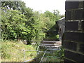
Steps down to the railway
Solely for the use of Network Rail staff. Electrification work here seems to be complete but is not yet commissioned.
Image: © Jonathan Thacker
Taken: 2 Sep 2019
0.04 miles
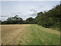
5
Thorney Lane
The bridleway which runs alongside the hedge on the left is called Thorney Lane.
Image: © Jonathan Thacker
Taken: 2 Sep 2019
0.10 miles
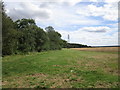
6
Stubble field and Bandy Slade
Bandy Slade is a small wood.
Image: © Jonathan Thacker
Taken: 2 Sep 2019
0.13 miles
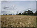
7
Bridleway alongside Oakley Purlieus
Image: © Jonathan Thacker
Taken: 2 Sep 2019
0.18 miles