IMAGES TAKEN NEAR TO
Ayr Close, CORBY, NN18 8QU
Introduction
This page details the photographs taken nearby to Ayr Close, NN18 8QU by members of the Geograph project.
The Geograph project started in 2005 with the aim of publishing, organising and preserving representative images for every square kilometre of Great Britain, Ireland and the Isle of Man.

There are currently over 7.5m images from over14,400 individuals and you can help contribute to the project by visiting https://www.geograph.org.uk
Image Map
Images are licensed for reuse under creativecommons.org/licenses/by-sa/2.0
Notes
- Clicking on the map will re-center to the selected point.
- The higher the marker number, the further away the image location is from the centre of the postcode.
Image Listing (1 Images Found)
Images are licensed for reuse under creativecommons.org/licenses/by-sa/2.0
Image
Details
Distance
1
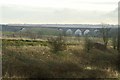
Railway viaduct near Great Oakley
Much of the land visible in front of the viaduct will eventually be swallowed up by the housing developments taking place in this area.
Image: © Blane Chalmers
Taken: 25 Feb 2007
0.19 miles