IMAGES TAKEN NEAR TO
Briery Close, CORBY, NN18 8JG
Introduction
This page details the photographs taken nearby to Briery Close, NN18 8JG by members of the Geograph project.
The Geograph project started in 2005 with the aim of publishing, organising and preserving representative images for every square kilometre of Great Britain, Ireland and the Isle of Man.

There are currently over 7.5m images from over14,400 individuals and you can help contribute to the project by visiting https://www.geograph.org.uk
Image Map
Images are licensed for reuse under creativecommons.org/licenses/by-sa/2.0
Notes
- Clicking on the map will re-center to the selected point.
- The higher the marker number, the further away the image location is from the centre of the postcode.
Image Listing (7 Images Found)
Images are licensed for reuse under creativecommons.org/licenses/by-sa/2.0
Image
Details
Distance
2
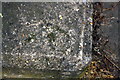
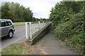
Benchmark on parapet of Oakley Road subway bridge
Ordnance Survey rivet benchmark described on the Bench Mark Database at www.bench-marks.org.uk/bm111634
Image: © phil Richards
Taken: 12 Sep 2019
0.19 miles
4
Entrance to subway from east side of Oakley Road
There is an OS benchmark Image on the near end of the concrete bridge parapet
Image: © phil Richards
Taken: 12 Sep 2019
0.22 miles
5
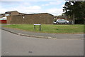
Garage block at junction of Flensburg Close and Copenhagen Road
Ordnance Survey records indicate that in 1983 there was a benchmark levelled at 112.978m above Newlyn Datum on the corner of the wall behind the tree trunk in front of the parked car
Image: © phil Richards
Taken: 12 Sep 2019
0.23 miles