IMAGES TAKEN NEAR TO
Church Drive, CORBY, NN18 8HB
Introduction
This page details the photographs taken nearby to Church Drive, NN18 8HB by members of the Geograph project.
The Geograph project started in 2005 with the aim of publishing, organising and preserving representative images for every square kilometre of Great Britain, Ireland and the Isle of Man.

There are currently over 7.5m images from over14,400 individuals and you can help contribute to the project by visiting https://www.geograph.org.uk
Image Map (Loading...)


Getting Data...Please wait
Leaflet Map data © OpenStreetMap
Images are licensed for reuse under creativecommons.org/licenses/by-sa/2.0
Notes
- Clicking on the map will re-center to the selected point.
- The higher the marker number, the further away the image location is from the centre of the postcode.
Image Listing (10 Images Found)
Images are licensed for reuse under creativecommons.org/licenses/by-sa/2.0
Image
Details
Distance
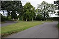
8
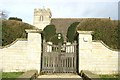
Estate entrance
Exotic gate and wall for a grass field so an assumption that it is or was connected with Gt Oakley Grange.
Image: © Michael Trolove
Taken: 17 Sep 2017
0.17 miles
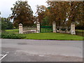
10
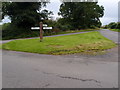
Road junction and grass triangle
As triangular as they come with a bit nibbled out by lazy drivers cutting corners.
Image: © Michael Trolove
Taken: 17 Sep 2017
0.18 miles