IMAGES TAKEN NEAR TO
Bideford Square, CORBY, NN18 8DW
Introduction
This page details the photographs taken nearby to Bideford Square, NN18 8DW by members of the Geograph project.
The Geograph project started in 2005 with the aim of publishing, organising and preserving representative images for every square kilometre of Great Britain, Ireland and the Isle of Man.

There are currently over 7.5m images from over14,400 individuals and you can help contribute to the project by visiting https://www.geograph.org.uk
Image Map (Loading...)


Getting Data...Please wait
Leaflet Map data © OpenStreetMap
Images are licensed for reuse under creativecommons.org/licenses/by-sa/2.0
Notes
- Clicking on the map will re-center to the selected point.
- The higher the marker number, the further away the image location is from the centre of the postcode.
Image Listing (6 Images Found)
Images are licensed for reuse under creativecommons.org/licenses/by-sa/2.0
Image
Details
Distance
1
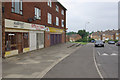
Burghley Drive, Corby
Corby is a strange contrast to the rather genteel Northamptonshire countryside that surrounds it, having developed as an industrial town around a steel works from the 1930s onwards. Many of the workers moved here from Scotland and were housed in estates such as this one.
Image: © Stephen McKay
Taken: 10 Jun 2007
0.12 miles

6
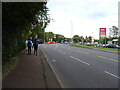
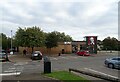
Approaching roundabout on Oakley Road (A6014)
Image: © JThomas
Taken: 27 Sep 2022
0.24 miles