IMAGES TAKEN NEAR TO
Beanfield Avenue, CORBY, NN18 0AZ
Introduction
This page details the photographs taken nearby to Beanfield Avenue, NN18 0AZ by members of the Geograph project.
The Geograph project started in 2005 with the aim of publishing, organising and preserving representative images for every square kilometre of Great Britain, Ireland and the Isle of Man.

There are currently over 7.5m images from over14,400 individuals and you can help contribute to the project by visiting https://www.geograph.org.uk
Image Map
Images are licensed for reuse under creativecommons.org/licenses/by-sa/2.0
Notes
- Clicking on the map will re-center to the selected point.
- The higher the marker number, the further away the image location is from the centre of the postcode.
Image Listing (34 Images Found)
Images are licensed for reuse under creativecommons.org/licenses/by-sa/2.0
Image
Details
Distance
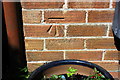
1
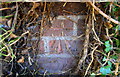
Benchmark on gatepost at entrance to St Brendan's Presbytery
Ordnance Survey cut mark benchmark described on the Bench Mark Database at www.bench-marks.org.uk/bm111614
Image: © phil Richards
Taken: 12 Sep 2019
0.03 miles
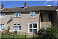
2
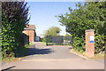
Entrance to St Brendan's Catholic Primary School from Beanfield Avenue
There is an OS benchmark Image on the ivy-clad left hand brick gatepost
Image: © phil Richards
Taken: 12 Sep 2019
0.04 miles
3
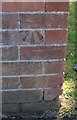
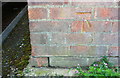
Benchmark on garage block on SE side of Caythorpe Square
Ordnance Survey cut mark benchmark described on the Bench Mark Database at www.bench-marks.org.uk/bm111615
Image: © phil Richards
Taken: 12 Sep 2019
0.06 miles
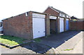
4
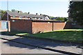
Garage block on SE side of Caythorpe Square at Mantlefield Road junction
There is an OS benchmark Image on the near corner, left hand face, of the block of garages
Image: © phil Richards
Taken: 12 Sep 2019
0.06 miles
5
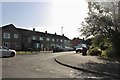
Taunton Avenue at the junction of Beanfield Avenue
Image: © David Howard
Taken: 29 Jun 2019
0.07 miles
8
Benchmark on #352 Cottingham Road
Ordnance Survey cut mark benchmark described on the Bench Mark Database at www.bench-marks.org.uk/bm107844
Image: © phil Richards
Taken: 10 May 2019
0.11 miles
9
Benchmark on garage block on NW side of Barton Square
Ordnance Survey cut mark benchmark described on the Bench Mark Database at www.bench-marks.org.uk/bm107601
Image: © Roger Templeman
Taken: 10 May 2019
0.12 miles
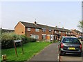
10
Garage blocks on NW side of Barton Square
There is an OS benchmark Image on the corner of the near block left of its doors
Image: © Roger Templeman
Taken: 10 May 2019
0.12 miles