IMAGES TAKEN NEAR TO
Manton Road, CORBY, NN17 4JL
Introduction
This page details the photographs taken nearby to Manton Road, NN17 4JL by members of the Geograph project.
The Geograph project started in 2005 with the aim of publishing, organising and preserving representative images for every square kilometre of Great Britain, Ireland and the Isle of Man.

There are currently over 7.5m images from over14,400 individuals and you can help contribute to the project by visiting https://www.geograph.org.uk
Image Map (Loading...)


Getting Data...Please wait
Leaflet Map data © OpenStreetMap
Images are licensed for reuse under creativecommons.org/licenses/by-sa/2.0
Notes
- Clicking on the map will re-center to the selected point.
- The higher the marker number, the further away the image location is from the centre of the postcode.
Image Listing (2 Images Found)
Images are licensed for reuse under creativecommons.org/licenses/by-sa/2.0
Image
Details
Distance
1
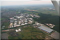
Industrial estate and power station by A6116 in Corby: aerial 2014
Image: © Chris
Taken: 2 Jul 2014
0.09 miles
2
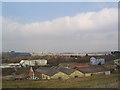
East side of Corby
Corby's rail freight line runs past the blue building on the right. The Weetabix factory is visible on the left horizon
Image: © Tim Heaton
Taken: 25 Mar 2007
0.10 miles