IMAGES TAKEN NEAR TO
Duckworth Road, CORBY, NN17 2RZ
Introduction
This page details the photographs taken nearby to Duckworth Road, NN17 2RZ by members of the Geograph project.
The Geograph project started in 2005 with the aim of publishing, organising and preserving representative images for every square kilometre of Great Britain, Ireland and the Isle of Man.

There are currently over 7.5m images from over14,400 individuals and you can help contribute to the project by visiting https://www.geograph.org.uk
Image Map
Images are licensed for reuse under creativecommons.org/licenses/by-sa/2.0
Notes
- Clicking on the map will re-center to the selected point.
- The higher the marker number, the further away the image location is from the centre of the postcode.
Image Listing (21 Images Found)
Images are licensed for reuse under creativecommons.org/licenses/by-sa/2.0
Image
Details
Distance
1
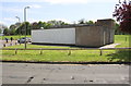
Community Centre in recreation ground off Collingwood Avenue
Image: © phil Richards
Taken: 10 May 2019
0.06 miles
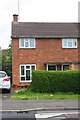
2
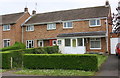
Nos.134 and 132 Kingsthorpe Avenue
There is an OS benchmark Image on the right hand side of the right hand house near its front corner
Image: © phil Richards
Taken: 10 May 2019
0.08 miles
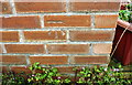
3
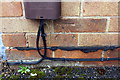
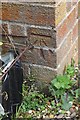
Benchmark (and Virgin Media box) on #132 Kingsthorpe Avenue
Ordnance Survey cut mark benchmark described on the Bench Mark Database at www.bench-marks.org.uk/bm107565
Image: © phil Richards
Taken: 10 May 2019
0.08 miles
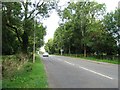
5
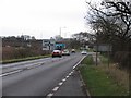
A6003/A427 roundabout
The roundabout is on the track of Via Devana which crosses the A6003 at this point.
Image: © Andrew Tatlow
Taken: 13 Dec 2006
0.15 miles
6
#178 Kingsthorpe Avenue
There is an OS benchmark Image on the left hand side of the house near its front corner
Image: © phil Richards
Taken: 10 May 2019
0.16 miles
7
Benchmark on #178 Kingsthorpe Avenue
Ordnance Survey cut mark benchmark described on the Bench Mark Database at www.bench-marks.org.uk/bm107568
Image: © phil Richards
Taken: 10 May 2019
0.16 miles
9

Electricity substation, Rayleigh Close
There is an OS benchmark Image on the corner of the building next to the wooden fence panel
Image: © phil Richards
Taken: 10 May 2019
0.19 miles
10
Benchmark on electricity substation on Rayleigh Close
Ordnance Survey cut mark benchmark described on the Bench Mark Database at www.bench-marks.org.uk/bm107563
Image: © phil Richards
Taken: 10 May 2019
0.19 miles