IMAGES TAKEN NEAR TO
Fotheringhay Road, CORBY, NN17 2RF
Introduction
This page details the photographs taken nearby to Fotheringhay Road, NN17 2RF by members of the Geograph project.
The Geograph project started in 2005 with the aim of publishing, organising and preserving representative images for every square kilometre of Great Britain, Ireland and the Isle of Man.

There are currently over 7.5m images from over14,400 individuals and you can help contribute to the project by visiting https://www.geograph.org.uk
Image Map (Loading...)


Getting Data...Please wait
Leaflet Map data © OpenStreetMap
Images are licensed for reuse under creativecommons.org/licenses/by-sa/2.0
Notes
- Clicking on the map will re-center to the selected point.
- The higher the marker number, the further away the image location is from the centre of the postcode.
Image Listing (15 Images Found)
Images are licensed for reuse under creativecommons.org/licenses/by-sa/2.0
Image
Details
Distance
1
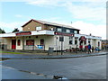
The Kingfisher
Estate pub of the same vintage as the surrounding housing, on the corner of Fotheringhay Road and Denford Road, West Corby.
Image: © Jonathan Billinger
Taken: 27 Jul 2009
0.08 miles
2
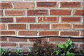
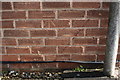
Benchmark on #1 Grendon Avenue
Ordnance Survey cut mark benchmark described on the Bench Mark Database at www.bench-marks.org.uk/bm107600
Image: © Roger Templeman
Taken: 10 May 2019
0.08 miles
3
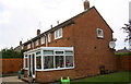
Houses of Grendon Avenue
There is an OS benchmark Image on the house wall right of the seat
Image: © Roger Templeman
Taken: 10 May 2019
0.09 miles
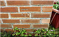
4
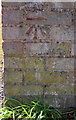
Benchmark on garage block on SW side of Fotheringhay Road
Ordnance Survey cut mark benchmark described on the Bench Mark Database at www.bench-marks.org.uk/bm107599
Image: © phil Richards
Taken: 10 May 2019
0.10 miles
5
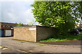
Garage block at junction of Wansford Place and Fotheringhay Road
There is an OS benchmark Image on the near corner, right hand face, of the block
Image: © phil Richards
Taken: 10 May 2019
0.10 miles
6
Benchmark on #178 Kingsthorpe Avenue
Ordnance Survey cut mark benchmark described on the Bench Mark Database at www.bench-marks.org.uk/bm107568
Image: © phil Richards
Taken: 10 May 2019
0.13 miles
7
#178 Kingsthorpe Avenue
There is an OS benchmark Image on the left hand side of the house near its front corner
Image: © phil Richards
Taken: 10 May 2019
0.13 miles
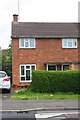
8
Nos. 54 and 52 Fotheringhay Road
There is an OS benchmark Image on the left hand face of the nearest house
Image: © Roger Templeman
Taken: 10 May 2019
0.17 miles
9
Benchmark on #54 Fotheringhay Road
Ordnance Survey cut mark benchmark described on the Bench Mark Database at www.bench-marks.org.uk/bm107567
Image: © Roger Templeman
Taken: 10 May 2019
0.18 miles
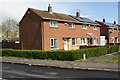
10
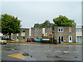
Housing on Shetland Way, Corby
1960's housing on the western outskirts of the town.
Image: © Jonathan Billinger
Taken: 27 Jul 2009
0.21 miles