IMAGES TAKEN NEAR TO
Deben Road, CORBY, NN17 2JY
Introduction
This page details the photographs taken nearby to Deben Road, NN17 2JY by members of the Geograph project.
The Geograph project started in 2005 with the aim of publishing, organising and preserving representative images for every square kilometre of Great Britain, Ireland and the Isle of Man.

There are currently over 7.5m images from over14,400 individuals and you can help contribute to the project by visiting https://www.geograph.org.uk
Image Map
Images are licensed for reuse under creativecommons.org/licenses/by-sa/2.0
Notes
- Clicking on the map will re-center to the selected point.
- The higher the marker number, the further away the image location is from the centre of the postcode.
Image Listing (19 Images Found)
Images are licensed for reuse under creativecommons.org/licenses/by-sa/2.0
Image
Details
Distance
1
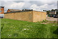
Garage block on east side of Deben Road
The concrete base to the right of the garage block is the site of a former electricity substation
Image: © phil Richards
Taken: 10 May 2019
0.03 miles
2
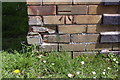
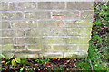
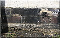
Benchmark on garage block at Test Green / Shire Road junction
Ordnance Survey cut mark benchmark described on the Bench Mark Database at www.bench-marks.org.uk/bm107556
Image: © phil Richards
Taken: 10 May 2019
0.09 miles
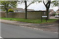
4
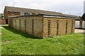
Garage block beside Test Green
There is an OS benchmark Image on the near corner, right hand face, of the block
Image: © phil Richards
Taken: 10 May 2019
0.09 miles
5
Benchmark on garage block at NW side of Tay Close
Ordnance Survey cut mark benchmark described on the Bench Mark Database at www.bench-marks.org/bm107558
Image: © phil Richards
Taken: 10 May 2019
0.11 miles
6
Garage block at Tay Close / Shire Road junction
There is an OS benchmark Image on the near corner, left hand face, of the garage block
Image: © phil Richards
Taken: 10 May 2019
0.11 miles
8
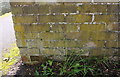
Benchmark on electricity substation on south side of Shire Road
Ordnance Survey cut mark benchmark described on the Bench Mark Database at www.bench-marks.org.uk/bm107555
Image: © phil Richards
Taken: 10 May 2019
0.14 miles
9
Benchmark on shed of #62 Willow Brook Road
Ordnance Survey cut mark benchmark described on the Bench Mark Database at www.bench-marks.org.uk/bm107557
Image: © phil Richards
Taken: 10 May 2019
0.14 miles
10
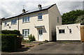
Nos. 64 and 62 Willow Brook Road
There is an OS benchmark Image on the front of the shed beside the right hand house
Image: © phil Richards
Taken: 10 May 2019
0.14 miles