IMAGES TAKEN NEAR TO
Woodfield Grove, CORBY, NN17 1ES
Introduction
This page details the photographs taken nearby to Woodfield Grove, NN17 1ES by members of the Geograph project.
The Geograph project started in 2005 with the aim of publishing, organising and preserving representative images for every square kilometre of Great Britain, Ireland and the Isle of Man.

There are currently over 7.5m images from over14,400 individuals and you can help contribute to the project by visiting https://www.geograph.org.uk
Image Map (Loading...)


Getting Data...Please wait
Leaflet Map data © OpenStreetMap
Images are licensed for reuse under creativecommons.org/licenses/by-sa/2.0
Notes
- Clicking on the map will re-center to the selected point.
- The higher the marker number, the further away the image location is from the centre of the postcode.
Image Listing (19 Images Found)
Images are licensed for reuse under creativecommons.org/licenses/by-sa/2.0
Image
Details
Distance
1
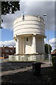
Water tower in middle of Tanfields Grove
Image: © Roger Templeman
Taken: 13 Sep 2018
0.03 miles
2
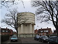
Water tower roundabout
Corby's hilltop location has resulted in this unusual situation.
Image: © Tim Heaton
Taken: 28 Jan 2007
0.04 miles
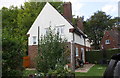
4
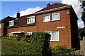
#44 Occupation Road
There is an OS benchmark Image on the right hand side of the house near the front corner
Image: © Roger Templeman
Taken: 13 Sep 2018
0.10 miles
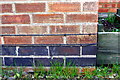
5
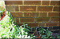
Benchmark on #44 Occupation Road
Ordnance Survey cut mark benchmark described on the Bench Mark Database at https://www.bench-marks.org.uk/bm99588
Image: © Roger Templeman
Taken: 13 Sep 2018
0.10 miles
6
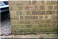
Benchmark on garage block on west side of West Glebe Road
Ordnance Survey cut mark benchmark described on the Bench Mark Database at https://www.bench-marks.org.uk/bm99589
Image: © Roger Templeman
Taken: 13 Sep 2018
0.11 miles
7
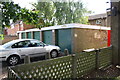
Garage block beside West Glebe Road
There is an OS benchmark Image on the near corner, right hand face, of the block
Image: © Roger Templeman
Taken: 13 Sep 2018
0.11 miles
8
#2 Westfields Road
There is an OS benchmark Image to the right of the wooden gate
Image: © Roger Templeman
Taken: 13 Sep 2018
0.15 miles
9
Benchmark on #2 Westfields Road
Ordnance Survey cut mark benchmark described on the Bench Mark Database at https://www.bench-marks.org.uk/bm99590
Image: © Roger Templeman
Taken: 13 Sep 2018
0.15 miles
10
Benchmark on #115 Occupation Road
Ordnance Survey cut mark benchmark described on the Bench Mark Database at https://www.bench-marks.org.uk/bm99587
Image: © Roger Templeman
Taken: 13 Sep 2018
0.19 miles