IMAGES TAKEN NEAR TO
Occupation Road, CORBY, NN17 1EQ
Introduction
This page details the photographs taken nearby to Occupation Road, NN17 1EQ by members of the Geograph project.
The Geograph project started in 2005 with the aim of publishing, organising and preserving representative images for every square kilometre of Great Britain, Ireland and the Isle of Man.

There are currently over 7.5m images from over14,400 individuals and you can help contribute to the project by visiting https://www.geograph.org.uk
Image Map
Images are licensed for reuse under creativecommons.org/licenses/by-sa/2.0
Notes
- Clicking on the map will re-center to the selected point.
- The higher the marker number, the further away the image location is from the centre of the postcode.
Image Listing (25 Images Found)
Images are licensed for reuse under creativecommons.org/licenses/by-sa/2.0
Image
Details
Distance
1
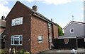
#145 Occupation Road
There is an OS benchmark Image on the near corner, right hand face, of the house
Image: © Roger Templeman
Taken: 13 Sep 2018
0.05 miles
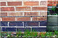
2
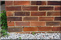
Benchmark on #145 Occupation Road
Ordnance Survey cut mark benchmark described on the Bench Mark Database at https://www.bench-marks.org.uk/bm99586
Image: © Roger Templeman
Taken: 13 Sep 2018
0.05 miles
3
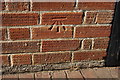
Benchmark on #278 Studfall Avenue
Ordnance Survey cut mark benchmark described on the Bench Mark Database at https://www.bench-marks.org.uk/bm99577
Image: © Roger Templeman
Taken: 13 Sep 2018
0.08 miles
4
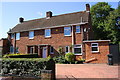
Semi-detached houses on Studfall Avenue
There is an OS benchmark Image on the extension of the right hand house, left of the wheelie bin
Image: © Roger Templeman
Taken: 13 Sep 2018
0.08 miles
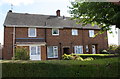
5

#254 Studfall Avenue with extension
Image: © Roger Templeman
Taken: 13 Sep 2018
0.11 miles
6
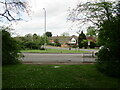
Cottingham Road and Studfall Avenue, Corby
Image: © Jonathan Thacker
Taken: 8 May 2022
0.13 miles
7
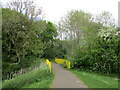
Footpath and footbridge, Corby
Thoroughsale Wood.
Image: © Jonathan Thacker
Taken: 8 May 2022
0.14 miles
8
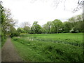
Path alongside a drain off Cottingham Road, Corby
Image: © Jonathan Thacker
Taken: 8 May 2022
0.14 miles
9
Semi-detached houses at Occupation Road / Eskdale Avenue junction
There is an OS benchmark Image on the side of the left hand house near its front corner
Image: © Roger Templeman
Taken: 13 Sep 2018
0.17 miles
10
Benchmark on #115 Occupation Road
Ordnance Survey cut mark benchmark described on the Bench Mark Database at https://www.bench-marks.org.uk/bm99587
Image: © Roger Templeman
Taken: 13 Sep 2018
0.17 miles