IMAGES TAKEN NEAR TO
Windmill Avenue, KETTERING, NN15 7DG
Introduction
This page details the photographs taken nearby to Windmill Avenue, NN15 7DG by members of the Geograph project.
The Geograph project started in 2005 with the aim of publishing, organising and preserving representative images for every square kilometre of Great Britain, Ireland and the Isle of Man.

There are currently over 7.5m images from over14,400 individuals and you can help contribute to the project by visiting https://www.geograph.org.uk
Image Map
Images are licensed for reuse under creativecommons.org/licenses/by-sa/2.0
Notes
- Clicking on the map will re-center to the selected point.
- The higher the marker number, the further away the image location is from the centre of the postcode.
Image Listing (5 Images Found)
Images are licensed for reuse under creativecommons.org/licenses/by-sa/2.0
Image
Details
Distance
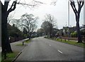
2
St Mary's Road, Kettering
Looking towards Elm Road
Image: © David Howard
Taken: 13 Sep 2020
0.20 miles
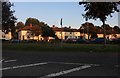
3
Houses on Elm Road, Kettering
From St Mary's Road
Image: © David Howard
Taken: 13 Sep 2020
0.22 miles
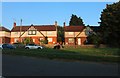
4
Kettering rugby club house
Sunday morning is junior rugby day across the country so boys and girls from 7 to 17 are playing, training or watching some form of rugby.
Image: © Michael Trolove
Taken: 24 Jan 2010
0.23 miles
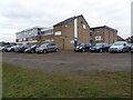
5
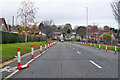
A6900 St Marys Road or St Mary's Road, Kettering
Temporary looking segregation of the cycle lanes over this stretch. The road name plates at each end differ in the use of an apostrophe.
Image: © Robin Webster
Taken: 5 Dec 2021
0.23 miles