IMAGES TAKEN NEAR TO
Pebbleford Road, KETTERING, NN15 6QE
Introduction
This page details the photographs taken nearby to Pebbleford Road, NN15 6QE by members of the Geograph project.
The Geograph project started in 2005 with the aim of publishing, organising and preserving representative images for every square kilometre of Great Britain, Ireland and the Isle of Man.

There are currently over 7.5m images from over14,400 individuals and you can help contribute to the project by visiting https://www.geograph.org.uk
Image Map
Images are licensed for reuse under creativecommons.org/licenses/by-sa/2.0
Notes
- Clicking on the map will re-center to the selected point.
- The higher the marker number, the further away the image location is from the centre of the postcode.
Image Listing (12 Images Found)
Images are licensed for reuse under creativecommons.org/licenses/by-sa/2.0
Image
Details
Distance
1
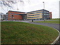
Tresham college, Kettering
A smart new look for the further education college in Kettering.
Image: © Michael Trolove
Taken: 24 Jan 2010
0.10 miles
2
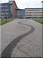
Pedestrian entrance to Tresham college
Can't imagine 17 year old lads wanting to skip into college down the wavy brick path but you never know.
Image: © Michael Trolove
Taken: 24 Jan 2010
0.13 miles
3
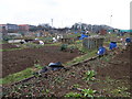
Kettering allotments
Allotments on Windmill Avenue.
Image: © Michael Trolove
Taken: 24 Jan 2010
0.13 miles
6
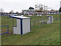
Touchline structures at Kettering rugby club
A couple of coaches shelters and a tv/video gantry for those important games adorn the side of the main pitch at Kettering rugby club.
Image: © Michael Trolove
Taken: 24 Jan 2010
0.19 miles
7
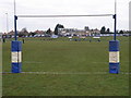
Kettering rugby club ground
A view across the first team pitch towards the club house.
Image: © Michael Trolove
Taken: 24 Jan 2010
0.21 miles
8
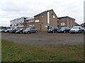
Kettering rugby club house
Sunday morning is junior rugby day across the country so boys and girls from 7 to 17 are playing, training or watching some form of rugby.
Image: © Michael Trolove
Taken: 24 Jan 2010
0.21 miles
9
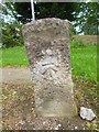
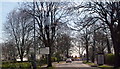
Old Milestone by the A6003, Barton Road, Kettering
Carved stone post by the A6003 (was A6), in parish of Kettering (Kettering District), Barton Road, at entrance to Wickstead Park, on verge, on South side of road. Kettering stone, erected by the Market Harborough & Brampton turnpike trust in the 19th century.
Inscription once read:-
: (TO / KETTER / ING / 1 / MILE) : : (TO / THRAP / STON / 8 / MILES) :
Carved benchmark on face.
Milestone Society National ID: NR_KTTH01
Image: © J Ward
Taken: 1 Nov 2005
0.21 miles
10
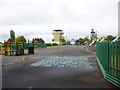
Kettering, play area
At Wicksteed Park: http://www.wicksteedpark.co.uk/?gclid=CPWvvNHGqL4CFZShtAodeGMA_g
Image: © Mike Faherty
Taken: 11 May 2014
0.22 miles