IMAGES TAKEN NEAR TO
Castle Mews, Chancery Lane, NN14 4SQ
Introduction
This page details the photographs taken nearby to Castle Mews, Chancery Lane, NN14 4SQ by members of the Geograph project.
The Geograph project started in 2005 with the aim of publishing, organising and preserving representative images for every square kilometre of Great Britain, Ireland and the Isle of Man.

There are currently over 7.5m images from over14,400 individuals and you can help contribute to the project by visiting https://www.geograph.org.uk
Image Map
Images are licensed for reuse under creativecommons.org/licenses/by-sa/2.0
Notes
- Clicking on the map will re-center to the selected point.
- The higher the marker number, the further away the image location is from the centre of the postcode.
Image Listing (72 Images Found)
Images are licensed for reuse under creativecommons.org/licenses/by-sa/2.0
Image
Details
Distance
1
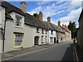
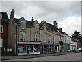
Chancery Lane, Thrapston
Eighteenth and nineteenth century houses. All are listed buildings.
Image: © Jonathan Thacker
Taken: 28 Jun 2020
0.03 miles
2
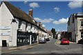
Chancery Lane, Thrapston
A minor road in the town centre.
The name is a well known one, no doubt because of Chancery Lane station on the London Underground, but what does Chancery mean?
It seems to get quite complex when you start looking at stuff about courts of law, but it can also mean something like a Public Record Office, which is probably the most likely explanation here.
Image: © Des Blenkinsopp
Taken: 17 Aug 2023
0.04 miles
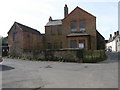
3
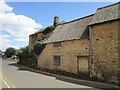
Derelict cottage, Chancery Lane, Thrapston
Image: © Jonathan Thacker
Taken: 28 Jun 2020
0.05 miles
4
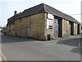
Chancery Autos, Thrapston
This was probably outbuildings to premises on the High Street.
Image: © Jonathan Thacker
Taken: 28 Jun 2020
0.05 miles
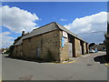
5
Chancery Auto's in Chancery lane
A garage with big doors, could have been a truck or bus garage possibly.
Image: © Michael Trolove
Taken: 3 Apr 2011
0.05 miles
6
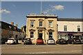
Former Barclay's Bank
Former Barclay's Bank at 41 High Street, Thrapston, now a charity shop
Image: © Richard Croft
Taken: 10 Aug 2023
0.06 miles
7
Boarded up in Chancery Lane
Old property well and truly sealed up in the heart of Thrapston.
Image: © Michael Trolove
Taken: 3 Apr 2011
0.06 miles
9
High Street, Thrapston
Buildings on the south side of the street.
Image: © Jonathan Thacker
Taken: 28 Jun 2020
0.07 miles
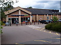
10
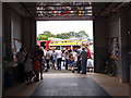
Thrapston Fire Station
Northamptonshire Fire and Rescue showing off the fire tender to the Charter Fair public.
King John granted Thrapston a market charter in 1205. This was awarded on the price of two palfreys (not a breed of horse but a style of movement, not trotting but an ambling gait) Every year the market status is celebrated with a street fair. Thrapston is the only town in Northamptonshire with a livestock market still within the town.
Image: © Michael Trolove
Taken: 30 Jun 2012
0.07 miles