IMAGES TAKEN NEAR TO
Park Walk, KETTERING, NN14 3HH
Introduction
This page details the photographs taken nearby to Park Walk, NN14 3HH by members of the Geograph project.
The Geograph project started in 2005 with the aim of publishing, organising and preserving representative images for every square kilometre of Great Britain, Ireland and the Isle of Man.

There are currently over 7.5m images from over14,400 individuals and you can help contribute to the project by visiting https://www.geograph.org.uk
Image Map (Loading...)


Getting Data...Please wait
Leaflet Map data © OpenStreetMap
Images are licensed for reuse under creativecommons.org/licenses/by-sa/2.0
Notes
- Clicking on the map will re-center to the selected point.
- The higher the marker number, the further away the image location is from the centre of the postcode.
Image Listing (69 Images Found)
Images are licensed for reuse under creativecommons.org/licenses/by-sa/2.0
Image
Details
Distance
1
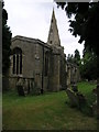
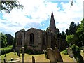
St Andrew's
The parish church in Brigstock is dedicated to St Andrew the Apostle. A sign directing you to the church suggests Saxon origins.
Image: © Michael Patterson
Taken: 14 Jun 2006
0.07 miles
2
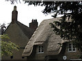
Brigstock: new thatch
New thatch on a limestone cottage near the church.
Image: © John Sutton
Taken: 1 Jun 2011
0.09 miles
3
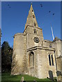
Bell Tower and Spire
Brigstock Church on a glorious February day.
Image: © Michael Trolove
Taken: 21 Feb 2009
0.12 miles
4
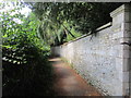
Footpath from the church, Brigstock
Leads to Park Walk.
Image: © Jonathan Thacker
Taken: 29 Jul 2019
0.12 miles
5
St Andrew's church, Brigstock
The lower part of the tower is C10 whilst the rest of the church was built between the C12 and C14. Restoration was carried out in C19.
Image: © Bikeboy
Taken: 27 Jun 2015
0.13 miles
6
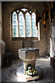
St.Andrew's font
Late 12th - early 13th century octagonal font in St.Andrew's church
Image: © Richard Croft
Taken: 9 Aug 2011
0.14 miles
7
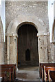
Tower arch
St.Andrew's 10th century Anglo-Saxon tower arch with the door to the stair turret beyond
Image: © Richard Croft
Taken: 9 Aug 2011
0.14 miles
8
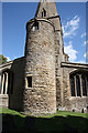
Anglo-Saxon stair turret
10th century Saxon stair turret to St.Andrew's tower, a great rarity, though others exist at Brixworth http://www.geograph.org.uk/photo/661702 Hough-on-the-Hill http://www.geograph.org.uk/photo/1400578 and Broughton http://www.geograph.org.uk/photo/50435
Image: © Richard Croft
Taken: 9 Aug 2011
0.14 miles
9
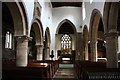
St.Andrew's nave
Looking east with Norman and Early English arcades in St.Andrew's church
Image: © Richard Croft
Taken: 9 Aug 2011
0.15 miles
10
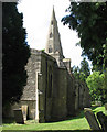
Brigstock: St Andrew
The earliest parts of the church date from the late 10th or early 11th centuries, and may incorporate material from an even more ancient church destroyed in the Danish invasions of the 9th century. The north arcade dates from the late 12th century and there is much from the 13th, 14th and 15th centuries, including the broach spire. The church is surrounded by trees, so difficult to photograph in its entirety.
Image: © John Sutton
Taken: 1 Jun 2011
0.15 miles