IMAGES TAKEN NEAR TO
Slipton Lane, KETTERING, NN14 3FH
Introduction
This page details the photographs taken nearby to Slipton Lane, NN14 3FH by members of the Geograph project.
The Geograph project started in 2005 with the aim of publishing, organising and preserving representative images for every square kilometre of Great Britain, Ireland and the Isle of Man.

There are currently over 7.5m images from over14,400 individuals and you can help contribute to the project by visiting https://www.geograph.org.uk
Image Map (Loading...)


Getting Data...Please wait
Leaflet Map data © OpenStreetMap
Images are licensed for reuse under creativecommons.org/licenses/by-sa/2.0
Notes
- Clicking on the map will re-center to the selected point.
- The higher the marker number, the further away the image location is from the centre of the postcode.
Image Listing (18 Images Found)
Images are licensed for reuse under creativecommons.org/licenses/by-sa/2.0
Image
Details
Distance
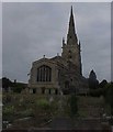
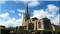
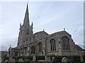
4
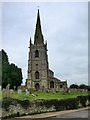
Church of St Nicholas, Islip
The Church has American connections - in the chancel is a monument to Mary Washington, whose husband John was uncle of the John Laurence Washington who sailed to America in 1657, becoming the great-granfather of the President.
Image: © Will Lovell
Taken: 29 Mar 2006
0.12 miles
7
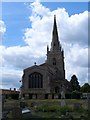
St Nicholas' church, Islip
This church was built almost entirely in the C15. It was restored 1854-55.
Image: © Bikeboy
Taken: 30 May 2015
0.14 miles
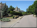
10
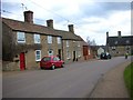
Lowick Road Islip
Looking south-east down Lowick Road to the Rose & Crown PH (closed at present) which stands at the junction of Mill Road and High Street. The Nene Way footpath goes down the pub garden.
Image: © Will Lovell
Taken: 30 Mar 2006
0.15 miles