IMAGES TAKEN NEAR TO
Woodwell Cottages, KETTERING, NN14 3AN
Introduction
This page details the photographs taken nearby to Woodwell Cottages, NN14 3AN by members of the Geograph project.
The Geograph project started in 2005 with the aim of publishing, organising and preserving representative images for every square kilometre of Great Britain, Ireland and the Isle of Man.

There are currently over 7.5m images from over14,400 individuals and you can help contribute to the project by visiting https://www.geograph.org.uk
Image Map
Images are licensed for reuse under creativecommons.org/licenses/by-sa/2.0
Notes
- Clicking on the map will re-center to the selected point.
- The higher the marker number, the further away the image location is from the centre of the postcode.
Image Listing (6 Images Found)
Images are licensed for reuse under creativecommons.org/licenses/by-sa/2.0
Image
Details
Distance
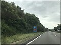
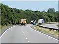
1
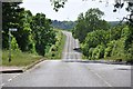
By the turn for Woodwell
The Kettering Road near Woodford, Northamptonshire, with the wind turbine in the distance.
Image: © MJ Reilly
Taken: 31 May 2009
0.18 miles
3
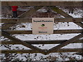
Twywell Plantation
Woodland Trust sign at the entrance to Twywell Plantation, an unreclaimed Ironstone pit and workings left as a nature reserve. http://www.woodlandtrust.org.uk/en/our-woods/Pages/wood-details.aspx?wood=4683#.UPgypye6fTo
Image: © Michael Trolove
Taken: 16 Jan 2013
0.21 miles

5
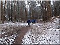
Walking through Twywell Plantation
A Woodland Trust site http://www.woodlandtrust.org.uk/en/our-woods/Pages/wood-details.aspx?wood=4683#.UPgypye6fTo
Image: © Michael Trolove
Taken: 16 Jan 2013
0.23 miles