IMAGES TAKEN NEAR TO
Speedwell Road, KETTERING, NN14 2JH
Introduction
This page details the photographs taken nearby to Speedwell Road, NN14 2JH by members of the Geograph project.
The Geograph project started in 2005 with the aim of publishing, organising and preserving representative images for every square kilometre of Great Britain, Ireland and the Isle of Man.

There are currently over 7.5m images from over14,400 individuals and you can help contribute to the project by visiting https://www.geograph.org.uk
Image Map (Loading...)


Getting Data...Please wait
Leaflet Map data © OpenStreetMap
Images are licensed for reuse under creativecommons.org/licenses/by-sa/2.0
Notes
- Clicking on the map will re-center to the selected point.
- The higher the marker number, the further away the image location is from the centre of the postcode.
Image Listing (2 Images Found)
Images are licensed for reuse under creativecommons.org/licenses/by-sa/2.0
Image
Details
Distance
1
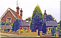
Former Desborough & Rothwell station
View northward, the railway line being the other side of the buildings: ex-Midland Main Line, London St Pancras - Leicester and the North. The station was closed 1/1/68.
Image: © Ben Brooksbank
Taken: 25 Aug 1993
0.22 miles
2
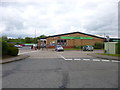
Desborough, The Co-operative Food
Off Station Road, on the site of the former station.
Image: © Mike Faherty
Taken: 9 May 2014
0.24 miles