IMAGES TAKEN NEAR TO
Old Gorse Way, KETTERING, NN14 1GJ
Introduction
This page details the photographs taken nearby to Old Gorse Way, NN14 1GJ by members of the Geograph project.
The Geograph project started in 2005 with the aim of publishing, organising and preserving representative images for every square kilometre of Great Britain, Ireland and the Isle of Man.

There are currently over 7.5m images from over14,400 individuals and you can help contribute to the project by visiting https://www.geograph.org.uk
Image Map
Images are licensed for reuse under creativecommons.org/licenses/by-sa/2.0
Notes
- Clicking on the map will re-center to the selected point.
- The higher the marker number, the further away the image location is from the centre of the postcode.
Image Listing (6 Images Found)
Images are licensed for reuse under creativecommons.org/licenses/by-sa/2.0
Image
Details
Distance
1
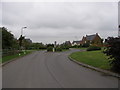
Entrance to the New Village of Mawsley.
Image: © Richard Williams
Taken: 25 May 2007
0.11 miles
3
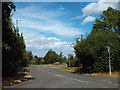
Loddington Way, Mawsley Village
Loddington Way is one of two roads leading into Mawsley Village. The village is newly-built, construction of the first houses started in 2001.
Image: © Malc McDonald
Taken: 28 Jul 2018
0.17 miles
4
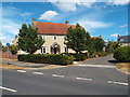
Mawsley Lodge, Mawsley Village
Mawsley Village is a new village in Northamptonshire. Construction of the village started in 2001.
Image: © Malc McDonald
Taken: 28 Jul 2018
0.20 miles
5
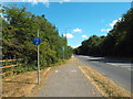
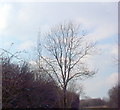
Cycle path near Mawsley Village
A cycle path alongside the road near Mawsley Village, in Northamptonshire.
Image: © Malc McDonald
Taken: 28 Jul 2018
0.22 miles
6
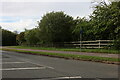
The road to Mawsley
The village is off on the right.
Image: © David Howard
Taken: 16 May 2021
0.24 miles