IMAGES TAKEN NEAR TO
St. Peters Road, BRACKLEY, NN13 7DB
Introduction
This page details the photographs taken nearby to St. Peters Road, NN13 7DB by members of the Geograph project.
The Geograph project started in 2005 with the aim of publishing, organising and preserving representative images for every square kilometre of Great Britain, Ireland and the Isle of Man.

There are currently over 7.5m images from over14,400 individuals and you can help contribute to the project by visiting https://www.geograph.org.uk
Image Map
Images are licensed for reuse under creativecommons.org/licenses/by-sa/2.0
Notes
- Clicking on the map will re-center to the selected point.
- The higher the marker number, the further away the image location is from the centre of the postcode.
Image Listing (18 Images Found)
Images are licensed for reuse under creativecommons.org/licenses/by-sa/2.0
Image
Details
Distance
1
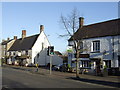
The Bell and opposite, The Greyhound, Brackley
The Greyhound once had a fantastic reputation for its numerous well kept beers. Sadly the couple responsible have now retired and things have been 'modernised' a bit.
Image: © al partington
Taken: 24 Jan 2008
0.10 miles
2
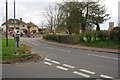
Junction of Church Road and Pebble Lane
On the left is the triangle which previously had a brick pillar postbox, replaced by a small metal box on a post. On the right is the railing enclosure of the Golden Spring, and the tower of St Peter's Church in the background.
Image: © Roger Templeman
Taken: 22 Apr 2013
0.11 miles
3
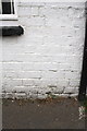
Benchmark on 'The Greyhound' pub, Church Road face
Ordnance Survey cut mark benchmark described on the Bench Mark Database at http://www.bench-marks.org.uk/bm48282
Image: © Roger Templeman
Taken: 22 Apr 2013
0.11 miles
4
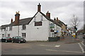
'The Greyhound' public house, #101 High Street
The pub is at the junction of High Street and Church Road. There is an OS benchmark Image on the side of the pub under the window at the left hand side of the image
Image: © Roger Templeman
Taken: 22 Apr 2013
0.11 miles
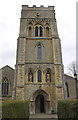
5
Benchmark on the tower of St Peter's Church
Ordnance Survey cut mark benchmark described on the Bench Mark Database at http://www.bench-marks.org.uk/bm48254
Image: © Roger Templeman
Taken: 22 Apr 2013
0.14 miles
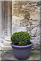
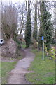
6
Hedge-lined path to St Peter's Church
There is an OS benchmark Image on the stonework to the right of the tower door, above the potted bush
Image: © Roger Templeman
Taken: 22 Apr 2013
0.14 miles
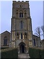

10
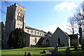
St Peter's, Brackley
The parish church for the parish of St Peter and St James. The latter is a reference to a chapel which has since disappeared. Notice that the triangular tops of the extension's windows do not match the curved ones of the original building.
Image: © Andrew Smith
Taken: 25 Mar 2006
0.16 miles