IMAGES TAKEN NEAR TO
Fulwell Lane, BRACKLEY, NN13 5RW
Introduction
This page details the photographs taken nearby to Fulwell Lane, NN13 5RW by members of the Geograph project.
The Geograph project started in 2005 with the aim of publishing, organising and preserving representative images for every square kilometre of Great Britain, Ireland and the Isle of Man.

There are currently over 7.5m images from over14,400 individuals and you can help contribute to the project by visiting https://www.geograph.org.uk
Image Map
Images are licensed for reuse under creativecommons.org/licenses/by-sa/2.0
Notes
- Clicking on the map will re-center to the selected point.
- The higher the marker number, the further away the image location is from the centre of the postcode.
Image Listing (8 Images Found)
Images are licensed for reuse under creativecommons.org/licenses/by-sa/2.0
Image
Details
Distance
2
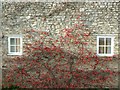
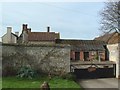
Mixbury Lodge Farm
House wall at Mixbury Lodge Farm
Image: © Snidge
Taken: 15 Feb 2007
0.03 miles
3
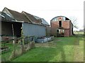
Mixbury Lodge Farm
Barn at Mixbury Lodge Farm
Image: © Snidge
Taken: 15 Feb 2007
0.03 miles
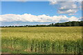
5
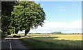
Lane and field in Mixbury
This is the continuation of Featherbed Lane
Image: © David Howard
Taken: 13 Jun 2020
0.15 miles
7
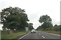
Cherwell : The A421
The A421 heading through the Cherwell District.
Image: © Lewis Clarke
Taken: 18 Mar 2019
0.18 miles
8
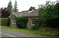
Old Toll House, Finmere
Toll House in the parish of Finmere, The Toll Cottage, Featherbed Lane, MK18.
Surveyed
Milestone Society National ID: OX.FIN
Image: © Alan Rosevear
Taken: Unknown
0.19 miles