IMAGES TAKEN NEAR TO
Juniper Hill, BRACKLEY, NN13 5RH
Introduction
This page details the photographs taken nearby to NN13 5RH by members of the Geograph project.
The Geograph project started in 2005 with the aim of publishing, organising and preserving representative images for every square kilometre of Great Britain, Ireland and the Isle of Man.

There are currently over 7.5m images from over14,400 individuals and you can help contribute to the project by visiting https://www.geograph.org.uk
Image Map
Images are licensed for reuse under creativecommons.org/licenses/by-sa/2.0
Notes
- Clicking on the map will re-center to the selected point.
- The higher the marker number, the further away the image location is from the centre of the postcode.
Image Listing (18 Images Found)
Images are licensed for reuse under creativecommons.org/licenses/by-sa/2.0
Image
Details
Distance
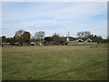
5
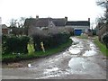
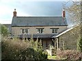
Juniper Hill
Cottages in the tiny hamlet of Juniper Hill
Image: © Snidge
Taken: 21 Feb 2007
0.03 miles
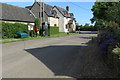
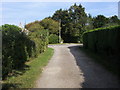
6
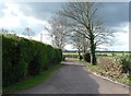
Juniper Hill
Road in Juniper Hill with the A43 traffic in the background
Image: © Snidge
Taken: 21 Feb 2007
0.04 miles
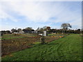
10
Seven Shires Way
Seven Shires Way footpath from Cottisford Heath at Juniper Hill
Image: © Shaun Ferguson
Taken: 1 Oct 2011
0.05 miles