IMAGES TAKEN NEAR TO
Highbridge Road, TOWCESTER, NN12 8SL
Introduction
This page details the photographs taken nearby to Highbridge Road, NN12 8SL by members of the Geograph project.
The Geograph project started in 2005 with the aim of publishing, organising and preserving representative images for every square kilometre of Great Britain, Ireland and the Isle of Man.

There are currently over 7.5m images from over14,400 individuals and you can help contribute to the project by visiting https://www.geograph.org.uk
Image Map
Images are licensed for reuse under creativecommons.org/licenses/by-sa/2.0
Notes
- Clicking on the map will re-center to the selected point.
- The higher the marker number, the further away the image location is from the centre of the postcode.
Image Listing (25 Images Found)
Images are licensed for reuse under creativecommons.org/licenses/by-sa/2.0
Image
Details
Distance
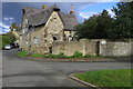
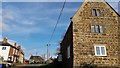
1

Wappenham High Street
Large house on High Street.
Image: © Ian Rob
Taken: 7 Jul 2012
0.04 miles
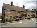
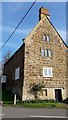
3
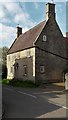
High Street, Wappenham
A handsome 17th century farmhouse with the extremely steep roof characteristic of western Northants.
Image: © Chris Brown
Taken: 5 Apr 2017
0.05 miles
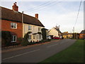
5
Wappenham Greenside
Cottages opposite the church.
Image: © Ian Rob
Taken: 7 Jul 2012
0.05 miles
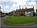
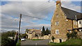
6
Greenside, Wappenham
Both the Old Bull and the farmhouse looking down from the top of the slope are listed as early 18th century.
Image: © Chris Brown
Taken: 5 Apr 2017
0.05 miles
7
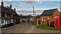
Greenside, Wappenham
Leading into the High Street.
Image: © Chris Brown
Taken: 5 Apr 2017
0.05 miles
8
Helmdon Road, Wappenham
At the bottom of the turn up into Greenside.
Image: © Chris Brown
Taken: 5 Apr 2017
0.06 miles
9
Wappenham High Street
Cottages on High Street.The one on the left was formerly The Chequers Public House.
Image: © Ian Rob
Taken: 7 Jul 2012
0.06 miles
10
The Old Bull, Wappenham
A former inn at the bottom of Greenside.
Image: © Chris Brown
Taken: 5 Apr 2017
0.07 miles