IMAGES TAKEN NEAR TO
Stoke Bruerne, TOWCESTER, NN12 7RL
Introduction
This page details the photographs taken nearby to NN12 7RL by members of the Geograph project.
The Geograph project started in 2005 with the aim of publishing, organising and preserving representative images for every square kilometre of Great Britain, Ireland and the Isle of Man.

There are currently over 7.5m images from over14,400 individuals and you can help contribute to the project by visiting https://www.geograph.org.uk
Image Map
Images are licensed for reuse under creativecommons.org/licenses/by-sa/2.0
Notes
- Clicking on the map will re-center to the selected point.
- The higher the marker number, the further away the image location is from the centre of the postcode.
Image Listing (44 Images Found)
Images are licensed for reuse under creativecommons.org/licenses/by-sa/2.0
Image
Details
Distance
1
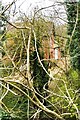
Stoke Bruerne Station through the trees
Stoke Bruerne Station complete with platform still stands, 70 years after its closure in 1952. Indeed it was only open for passengers between December 1892 and March 1893! It is a remnant of the Stratford & Midland Junction Railway, a line that could count its daily passengers on the fingers of one hand, but was really built for the ironstone traffic from Northamptonshire to the South Wales steel furnaces. After many hand to mouth years, the traffic dried up in the 1960's and the whole line was closed, save for a short stretch from Fenny Compton, used by the MOD.
Image: © Bob Walters
Taken: 4 Apr 2022
0.01 miles

4
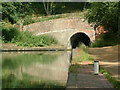
Southern portal of Blisworth Tunnel
Blisworth Tunnel is a tunnel on the Grand Union Canal between the villages of Stoke Bruerne (southern end) and Blisworth (northern end).
At 3076 yards (2813 metres) long it is the third-longest navigable canal tunnel on the UK canal network.
Construction started in 1793, but after three years work it collapsed due to quicksand, claiming the lives of fourteen men. It was then decided to begin again with a new tunnel, which was not complete until March 1805, five years after the rest of the canal was open. The gap was filled by a temporary horse-drawn tramway over the top of the hill, with goods being transported from boat to wagon and back again. The tramway, built in 1801, was Northamptonshire's first railway.
Image: © Stephen Dawson
Taken: 10 Jul 2004
0.07 miles

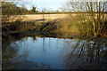
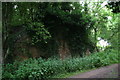
6
Abutments of old bridge, Stratford and Midland Junction railway
High above the line of Blisworth Canal Tunnel, and crossing it at right angles, ran the old Stratford and Midland Junction railway, closed and dismantled even before the days of Beeching. There are few remains, but the abutments of the bridge by which the railway crossed this minor unmetalled road were still there in 1974.
Image: © Dr Neil Clifton
Taken: 18 Apr 1974
0.11 miles
7
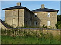
Stoke Plain Farmhouse
Grade II listed farmhouse dating from about 1840, located along Stoke Road, near the South Northamptonshire village of Stoke Bruerne.
Image: © Mat Fascione
Taken: 1 Aug 2015
0.15 miles
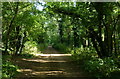
9
Abutments of old bridge, Stratford and Midland Junction railway
Above the line of Blisworth Canal Tunnel, and crossing it at right angles, ran the old Stratford and Midland Junction railway, closed and dismantled even before the days of Beeching. This is one of the abutments of the bridge by which the railway crossed this track.
See 1974 photo Image
Image: © Chris
Taken: 2 Jul 2014
0.16 miles
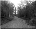
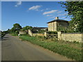
10
Track leading down to the Grand Union Canal
Image: © Mat Fascione
Taken: 1 Aug 2015
0.16 miles