IMAGES TAKEN NEAR TO
Towbury Lane, TOWCESTER, NN12 6FT
Introduction
This page details the photographs taken nearby to Towbury Lane, NN12 6FT by members of the Geograph project.
The Geograph project started in 2005 with the aim of publishing, organising and preserving representative images for every square kilometre of Great Britain, Ireland and the Isle of Man.

There are currently over 7.5m images from over14,400 individuals and you can help contribute to the project by visiting https://www.geograph.org.uk
Image Map
Images are licensed for reuse under creativecommons.org/licenses/by-sa/2.0
Notes
- Clicking on the map will re-center to the selected point.
- The higher the marker number, the further away the image location is from the centre of the postcode.
Image Listing (176 Images Found)
Images are licensed for reuse under creativecommons.org/licenses/by-sa/2.0
Image
Details
Distance
1
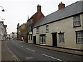
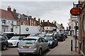
Towcester
A rare quiet spell on Watling Street East.
Image: © Ian Rob
Taken: 20 Feb 2007
0.01 miles
2
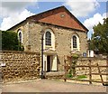
Roman Catholic Church, Meeting Lane, Towcester
This was built in 1846 as an Independent chapel, later Congregational. For a view of the side see http://www.imagesofengland.org.uk/images/23/51/L235147.jpg
Image: © Humphrey Bolton
Taken: 1 Jun 2007
0.01 miles
3
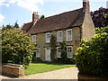
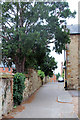
The Vicarage, Chantry Lane, Towcester
Built of limestone in the late 17C and extended in 1854.
Image: © Humphrey Bolton
Taken: 1 Jun 2007
0.01 miles
5
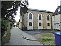
Towcester, Catholic church
St. Thomas More RC Church, on Meeting Lane. Former dissenting chapel, built 1846. Grade II listed by Historic England: https://historicengland.org.uk/listing/the-list/list-entry/1040848
Image: © Mike Faherty
Taken: 6 Oct 2019
0.01 miles
7

Watling Street passes Towcester Town Hall
Image: © Stuart Logan
Taken: 1 May 2013
0.03 miles
9
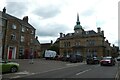
Towcester Town Hall
Looking across Watling Street towards the town hall.
Image: © DS Pugh
Taken: 29 May 2022
0.04 miles
10
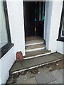
Post Office Telegraphs cable joint marker
VR-era (1897-1901) telegraph cable joint marker, at 179 Watling Street, Towcester. The marker indicates the position of a joint in the buried telegraph cable. Originally numerals would indicate the distance in feet and inches directly in front of the marker. This one is unusual in being placed on private property. It's likely the steps were built around it. Less than half the post is visible above ground. The cable route is the original London-Birmingham route, the first long-distance underground telegraph route in the UK. A large number of these markers remain in Towcester, swapping sides of the A5 several times.
Image: © Derek Pattenson
Taken: 23 Aug 2021
0.04 miles