IMAGES TAKEN NEAR TO
Packwood Close, DAVENTRY, NN11 8AJ
Introduction
This page details the photographs taken nearby to Packwood Close, NN11 8AJ by members of the Geograph project.
The Geograph project started in 2005 with the aim of publishing, organising and preserving representative images for every square kilometre of Great Britain, Ireland and the Isle of Man.

There are currently over 7.5m images from over14,400 individuals and you can help contribute to the project by visiting https://www.geograph.org.uk
Image Map
Images are licensed for reuse under creativecommons.org/licenses/by-sa/2.0
Notes
- Clicking on the map will re-center to the selected point.
- The higher the marker number, the further away the image location is from the centre of the postcode.
Image Listing (35 Images Found)
Images are licensed for reuse under creativecommons.org/licenses/by-sa/2.0
Image
Details
Distance
1
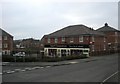
Middlemore Shops
Convenience Store on Farnborough Drive.
Image: © Ian Rob
Taken: 29 Jan 2011
0.05 miles
2
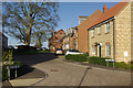
Knole Way, Middlemore
The streets on this new housing development are named after National Trust properties. It is pleasing to see that some of the original trees have been left in place, including the sycamore here.
Image: © Stephen McKay
Taken: 6 Jan 2008
0.05 miles
3
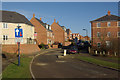
Farnborough Drive, Middlemore
Looking along Farnborough Drive - the main thoroughfare through this new estate.
Image: © Stephen McKay
Taken: 6 Jan 2008
0.05 miles
4

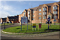
Daventry-Middlemore Estate
Housing on Farnborough Drive.
Image: © Ian Rob
Taken: 29 Jan 2011
0.06 miles
5
Middlemore
Looking along Farnborough Drive from its junction with Hidcote Way. Work on this large new housing development to the north of Daventry began in 2002 on land once part of Middlemore Farm.
Image: © Stephen McKay
Taken: 6 Jan 2008
0.06 miles
6
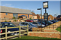
Middlemore Farm
Middlemore Farm and its associated buildings date from the 18th century and are listed. The farm's land is now being rapidly converted into a housing estate and the buildings have become a pub - appropriately called 'Middlemore Farm'; at least this preserves a link with the area's past. The pub sign depicts the farm as it used to be.
Image: © Stephen McKay
Taken: 6 Jan 2008
0.06 miles
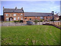
8
Daventry-Middlemore Farm
Farm buildings which have been converted to a public house. Looking from the bridleway.
Image: © Ian Rob
Taken: 29 Jan 2011
0.08 miles
9
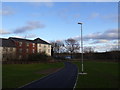
Daventry, Middlemore Pathway
A pathway in Middlemore near Daventry just opposite the Drayton Reservoir.
Image: © Jareth W
Taken: 3 Jan 2014
0.09 miles
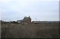
10
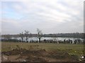
Daventry
Taken from new housing development north of Drayton Reservoir
Image: © Ian Rob
Taken: 10 Dec 2005
0.09 miles