IMAGES TAKEN NEAR TO
Coxs Lane, DAVENTRY, NN11 6LQ
Introduction
This page details the photographs taken nearby to Coxs Lane, NN11 6LQ by members of the Geograph project.
The Geograph project started in 2005 with the aim of publishing, organising and preserving representative images for every square kilometre of Great Britain, Ireland and the Isle of Man.

There are currently over 7.5m images from over14,400 individuals and you can help contribute to the project by visiting https://www.geograph.org.uk
Image Map
Images are licensed for reuse under creativecommons.org/licenses/by-sa/2.0
Notes
- Clicking on the map will re-center to the selected point.
- The higher the marker number, the further away the image location is from the centre of the postcode.
Image Listing (23 Images Found)
Images are licensed for reuse under creativecommons.org/licenses/by-sa/2.0
Image
Details
Distance
2
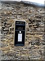
George VI Postbox painted black
This is set into the wall of Hellidon House and Lachetts. It is not a Post Office postbox and is just used for mail deliveries to the house. The wall dates from around 1800. (See http://www.britishlistedbuildings.co.uk/en-360585-hellidon-house-and-latchetts-walls-gatep#.Vedga_lViko for entry in British Listed Buildings).
Image: © Bikeboy
Taken: 20 Aug 2015
0.06 miles
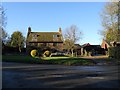
3
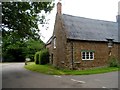
Green Farmhouse, Hellidon
Built in late C17. See http://www.britishlistedbuildings.co.uk/en-360583-green-farmhouse-hellidon-northamptonshir#.VedZw_lViko for entry in British Listed Buildings
Image: © Bikeboy
Taken: 20 Aug 2015
0.06 miles
4
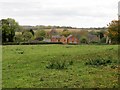
Hellidon-Berry Lane
Houses on Berry Lane, looking from Church Lane.
Image: © Ian Rob
Taken: 29 Oct 2011
0.06 miles
5
Hellidon-Berry Lane
Cottage at the junction with Stockwell Lane.
Image: © Ian Rob
Taken: 7 Dec 2012
0.07 miles
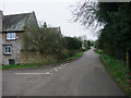
7
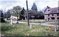
Road to Lower Catesby - Hellidon, Northamptonshire
A July day in the Northamptonshire village of Hellidon. The road north to Lower Catesby Image forms part of the Jurassic Way. This follows a band of limestone from Banbury Image in Oxfordshire for 88 miles to its opposite end at Stamford Image in Lincolnshire. The village is the source of the River Leam, which after 25 miles joins the River Avon Image just south of the A445 between Warwick and Leamington Spa, to give it its full title. The right hand arm of the signpost reads 'LOWER CATESBY GATED ROAD' and the left hand arm 'CHARWELTON 2'. Time photo taken not available.
Image: © Martin Richard Phelan
Taken: Unknown
0.07 miles
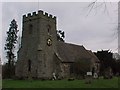
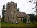
9
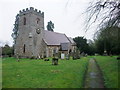
Church of St John the Baptist, Hellidon
http://professor-moriarty.com/moriarties/midland_churches/2008/10/25/hellidon/
Image: © Tim Heaton
Taken: 27 Feb 2011
0.08 miles
10
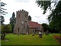
St John the Baptist, Hellidon
The church originates from C13/C14 and the tower is original. However the rest of the church was heavily restored by William Butterfield 1845-7.
Image: © Bikeboy
Taken: 20 Aug 2015
0.08 miles