IMAGES TAKEN NEAR TO
Hillside, DAVENTRY, NN11 4PJ
Introduction
This page details the photographs taken nearby to Hillside, NN11 4PJ by members of the Geograph project.
The Geograph project started in 2005 with the aim of publishing, organising and preserving representative images for every square kilometre of Great Britain, Ireland and the Isle of Man.

There are currently over 7.5m images from over14,400 individuals and you can help contribute to the project by visiting https://www.geograph.org.uk
Image Map
Images are licensed for reuse under creativecommons.org/licenses/by-sa/2.0
Notes
- Clicking on the map will re-center to the selected point.
- The higher the marker number, the further away the image location is from the centre of the postcode.
Image Listing (5 Images Found)
Images are licensed for reuse under creativecommons.org/licenses/by-sa/2.0
Image
Details
Distance
3
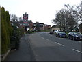
Daventry: Admirals Way
This is the view looking south at the junction with Birkdale Close from the upper deck of a D1 bus bound for Northampton.
Image: © Nigel Cox
Taken: 29 Jun 2015
0.14 miles
4
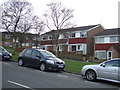
Daventry - Southbrook
Entrance to the estate looking north west to island on B4036
Image: © Ian Rob
Taken: 12 Jan 2006
0.14 miles
5
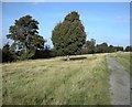
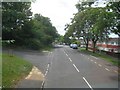
Daventry-Borough Hill
The path along the west side of the hill.
Image: © Ian Rob
Taken: 18 Oct 2009
0.22 miles