IMAGES TAKEN NEAR TO
Hinton Manor Court, DAVENTRY, NN11 3NU
Introduction
This page details the photographs taken nearby to Hinton Manor Court, NN11 3NU by members of the Geograph project.
The Geograph project started in 2005 with the aim of publishing, organising and preserving representative images for every square kilometre of Great Britain, Ireland and the Isle of Man.

There are currently over 7.5m images from over14,400 individuals and you can help contribute to the project by visiting https://www.geograph.org.uk
Image Map (Loading...)


Getting Data...Please wait
Leaflet Map data © OpenStreetMap
Images are licensed for reuse under creativecommons.org/licenses/by-sa/2.0
Notes
- Clicking on the map will re-center to the selected point.
- The higher the marker number, the further away the image location is from the centre of the postcode.
Image Listing (20 Images Found)
Images are licensed for reuse under creativecommons.org/licenses/by-sa/2.0
Image
Details
Distance
1
Woodford Halse Flood Warning Station
The River Cherwell, which is what's under the bridge, is prone to flooding over most of its length, from a few km. north of here right down into Oxford.
The Environment Agency have installed monitoring equipment in the green kiosk to raise an alarm when the river reaches a dangerous level.
Image: © Des Blenkinsopp
Taken: 21 Apr 2010
0.06 miles
3
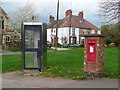
Woodford Halse: postbox № NN11 209, Hinton Green
This George V-reign postbox is set into a brick pillar and has a triangular telephone box for company at the edge of Hinton Green. The postbox is emptied finally at 4pm on weekdays and at 8:30am on Saturdays.
Image: © Chris Downer
Taken: 15 Apr 2011
0.07 miles
4
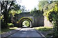
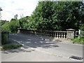
Railway bridges at Woodford Halse
These two bridges were built to take the Great Central Railway's London Extension across the road and into Woodford Halse Station. Two bridges were necessary as the tracks split to pass the station's island platform. The station, to the left, was accessed from the road via a staircase in the bridge abutment. Originally named Woodford and Hinton, the villages on either side of the line, the station was closed in the 1960's along with the whole London Extension line.
Image: © Bob Walters
Taken: 22 Sep 2021
0.08 miles
5
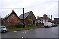
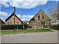
Chapels, Hinton
Wesleyan chapel, now a private residence, in red brick, and a browner Methodist church.
Image: © Andrew Smith
Taken: 26 Mar 2006
0.09 miles
6
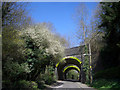
Bridge of Stripes
No trains have been through Woodford Halse for years, but these old bridges are still there as a reminder of steamier times.
They have recently been adorned with these black and yellow stripes which I think look quite nice, but bridge purists may disagree.
Image: © Des Blenkinsopp
Taken: 21 Apr 2010
0.09 miles
7
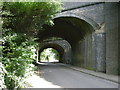
Woodford Halse
The twin bridges at the site of station on The Great Central Line.
Image: © Ian Rob
Taken: 15 Aug 2008
0.09 miles
8
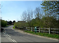
Woodford Halse
Bridge over stream in Station Road.
Image: © Ian Rob
Taken: 15 Aug 2008
0.10 miles
9
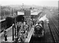
Woodford Halse station
An enthusiasts' train calls at Woodford Halse shortly before closure of the line
Image: © Flying Stag
Taken: Unknown
0.11 miles