IMAGES TAKEN NEAR TO
Osprey Drive, DAVENTRY, NN11 0XP
Introduction
This page details the photographs taken nearby to Osprey Drive, NN11 0XP by members of the Geograph project.
The Geograph project started in 2005 with the aim of publishing, organising and preserving representative images for every square kilometre of Great Britain, Ireland and the Isle of Man.

There are currently over 7.5m images from over14,400 individuals and you can help contribute to the project by visiting https://www.geograph.org.uk
Image Map
Images are licensed for reuse under creativecommons.org/licenses/by-sa/2.0
Notes
- Clicking on the map will re-center to the selected point.
- The higher the marker number, the further away the image location is from the centre of the postcode.
Image Listing (20 Images Found)
Images are licensed for reuse under creativecommons.org/licenses/by-sa/2.0
Image
Details
Distance
1
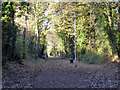
Path along old railway, Daventry
The former Weedon to Leamington line of the LNWR. It closed to passengers in 1958 and to freight over this part in 1963.
Image: © Robin Webster
Taken: 4 Dec 2016
0.04 miles
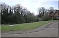
2
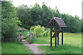
Orientation/interpretation point, western entrance to Daventry Country Park
Sadly, vandalized. The elevated A425 is in the background.
Image: © Robin Stott
Taken: 25 May 2007
0.05 miles
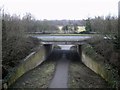
3
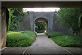
Pedestrian entrance to Daventry Country Park
This way into the park passes under a disused railway bridge, seen here from beneath the elevated A425.
Image: © Robin Stott
Taken: 25 May 2007
0.06 miles
4
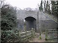
Daventry Dismantled Railway
A footpath leading into Daventry Country Park passes under the dismantled Leamington to Weedon Line, which is also used as a footpath heading roughly north from the Town centre.
Image: © Ian Rob
Taken: 11 Jan 2011
0.06 miles
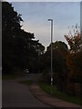
5
Daventry-Teal Close
Part of a small residential area backing on to the dismantled railway.
Image: © Ian Rob
Taken: 11 Jan 2011
0.06 miles
6
Daventry-Northern Way
Footpath under Northern way into the country park, looking from the railway bridge.
Image: © Ian Rob
Taken: 11 Jan 2011
0.09 miles
7
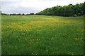
Meadow, west side of Daventry Country Park
With the elevated A425 in the background, right.
Image: © Robin Stott
Taken: 25 May 2007
0.11 miles
8
Teal Close, Daventry
The streets on this development are named after water birds. Daventry Reservoir is not far away.
Image: © Robin Webster
Taken: 4 Dec 2016
0.12 miles
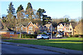
10
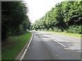
Daventry, Welton Road
Facing Northeast towards Daneholme Park followed by T junction surrounded by trees.
Image: © Jareth W
Taken: 31 Oct 2013
0.13 miles