IMAGES TAKEN NEAR TO
Kayes Court, NOTTINGHAM, NG9 8EB
Introduction
This page details the photographs taken nearby to Kayes Court, NG9 8EB by members of the Geograph project.
The Geograph project started in 2005 with the aim of publishing, organising and preserving representative images for every square kilometre of Great Britain, Ireland and the Isle of Man.

There are currently over 7.5m images from over14,400 individuals and you can help contribute to the project by visiting https://www.geograph.org.uk
Image Map
Images are licensed for reuse under creativecommons.org/licenses/by-sa/2.0
Notes
- Clicking on the map will re-center to the selected point.
- The higher the marker number, the further away the image location is from the centre of the postcode.
Image Listing (129 Images Found)
Images are licensed for reuse under creativecommons.org/licenses/by-sa/2.0
Image
Details
Distance
1
Stapleford Baptist Chapel, Albert Street
Built at a cost of £1,800 and opened on Good Friday 1878.
Image: © Andrew Abbott
Taken: 22 Mar 2020
0.03 miles
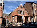
2

Former Lace Factory
On Albert Street, Stapleford.
Image: © Andrew Abbott
Taken: 22 Mar 2020
0.04 miles
3
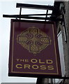
Sign for the Old Cross public house, Stapleford
Image: © JThomas
Taken: 9 Jul 2016
0.04 miles
4
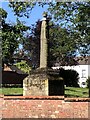
Stapleford’s Saxon Cross
Stapleford is an ancient town which has been subsumed into a suburb of Nottingham. It is included in the Domesday Book (without alteration to it name).
The word ‘staple’ is a Saxon word for a post next to a ford, and there is some speculation the Saxon Cross could be that post as there is no indication of a cross that has been removed from the top (although moved from its original site).
Stapleford is on the route of the prehistoric Derbyshire Portway which runs from the Hemlock Stone (as possible from a site near the Trent Bridge), to Mam Tor and beyond.
Image: © Lynn Jackson
Taken: 7 Jul 2023
0.04 miles
5
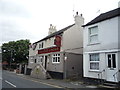
The Old Cross public house, Stapleford
On Church Street.
Image: © JThomas
Taken: 9 Jul 2016
0.04 miles
6
The Old Cross, Stapleford
Not the cross itself https://www.geograph.org.uk/snippet/17901 , but the pub of the same name, which faces it.
Image: © Alan Murray-Rust
Taken: 12 Jun 2018
0.04 miles
7
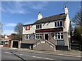
The Old Cross
Public House in Stapleford, named after the Anglo Saxon cross which sits opposite in the churchyard.
Image: © Andrew Abbott
Taken: 22 Mar 2020
0.04 miles
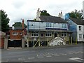
8

Whiteley Mill Hotel and Offices
Conversion of a former lace factory. The original 19th century factory is the brick section to the rear, now providing apartments. The white painted section was a 20th century extension, very much modernised and with the penthouse storey added around 2017.
Image: © Alan Murray-Rust
Taken: 12 Jun 2018
0.05 miles
9
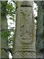
The Old Cross, Stapleford, (detail)
The unusual carved figure on the south face of the cross. Possibly one of the archangels, although local tradition identifies it as St Luke.
Image: © Alan Murray-Rust
Taken: 12 Jun 2018
0.05 miles
10
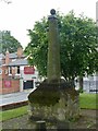
The Old Cross, Stapleford
The complete cross seen from the north west.
Image: © Alan Murray-Rust
Taken: 12 Jun 2018
0.05 miles