IMAGES TAKEN NEAR TO
Lower Orchard Street, NOTTINGHAM, NG9 8DH
Introduction
This page details the photographs taken nearby to Lower Orchard Street, NG9 8DH by members of the Geograph project.
The Geograph project started in 2005 with the aim of publishing, organising and preserving representative images for every square kilometre of Great Britain, Ireland and the Isle of Man.

There are currently over 7.5m images from over14,400 individuals and you can help contribute to the project by visiting https://www.geograph.org.uk
Image Map
Images are licensed for reuse under creativecommons.org/licenses/by-sa/2.0
Notes
- Clicking on the map will re-center to the selected point.
- The higher the marker number, the further away the image location is from the centre of the postcode.
Image Listing (129 Images Found)
Images are licensed for reuse under creativecommons.org/licenses/by-sa/2.0
Image
Details
Distance


3

Stapleford fire station
Stapleford fire station, Pinfold Lane, Stapleford, Nottingham is part of the Nottinghamshire Fire & Rescue Service.
Image: © Kevin Hale
Taken: 21 Jan 2007
0.05 miles
4

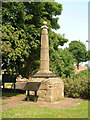
Stapleford’s Saxon Cross
Stapleford is an ancient town which has been subsumed into a suburb of Nottingham. It is included in the Domesday Book (without alteration to it name).
The word ‘staple’ is a Saxon word for a post next to a ford, and there is some speculation the Saxon Cross could be that post as there is no indication of a cross that has been removed from the top (although moved from its original site).
Stapleford is on the route of the prehistoric Derbyshire Portway which runs from the Hemlock Stone (as possible from a site near the Trent Bridge), to Mam Tor and beyond.
Image: © Lynn Jackson
Taken: 7 Jul 2023
0.05 miles
5
Anglo Saxon Cross, St Helen's Church
Image: © Jeff Tomlinson
Taken: 30 May 2003
0.07 miles
6

Stapleford Fire and Rescue station
A smallish station which has survived reorganisations. On Pinfold Lane.
Image: © Alan Murray-Rust
Taken: 12 Jun 2018
0.07 miles
7
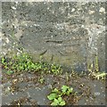
Bench mark, The Old Cross, Stapleford
See http://www.geograph.org.uk/photo/5808804 for location.
Image: © Alan Murray-Rust
Taken: 12 Jun 2018
0.07 miles
8
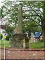
The Old Cross, Stapleford
The complete cross seen from the east.
There is a bench mark http://www.geograph.org.uk/photo/5808779 on the base just visible above the wall coping.
Image: © Alan Murray-Rust
Taken: 12 Jun 2018
0.07 miles

10

Pinfold Business Park, Stapleford
A collection of factory units close to Nottingham Road that has become a small business park whose main sign has seen better days.
Image: © Richard Vince
Taken: 7 Jul 2012
0.07 miles