IMAGES TAKEN NEAR TO
Bridgend Close, NOTTINGHAM, NG9 7BU
Introduction
This page details the photographs taken nearby to Bridgend Close, NG9 7BU by members of the Geograph project.
The Geograph project started in 2005 with the aim of publishing, organising and preserving representative images for every square kilometre of Great Britain, Ireland and the Isle of Man.

There are currently over 7.5m images from over14,400 individuals and you can help contribute to the project by visiting https://www.geograph.org.uk
Image Map
Images are licensed for reuse under creativecommons.org/licenses/by-sa/2.0
Notes
- Clicking on the map will re-center to the selected point.
- The higher the marker number, the further away the image location is from the centre of the postcode.
Image Listing (46 Images Found)
Images are licensed for reuse under creativecommons.org/licenses/by-sa/2.0
Image
Details
Distance
1
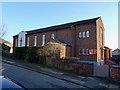
Catholic Church of St. John the Evangelist
Built in 1951/52 to serve the independent parish of Stapleford. Downgraded, since 2003, to a chapel of ease to Ilkeston.
Image: © Ian Calderwood
Taken: 18 Nov 2018
0.06 miles
2
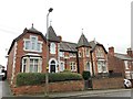
60 and 62 Brookhill Street, Stapleford
Monrepos from 1888
Image: © Andrew Abbott
Taken: 28 Dec 2019
0.08 miles
3
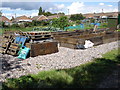
Bessell Lane Allotments, Stapleford
These allotments are sandwiched between housing in Stapleford and industry further down Bessell Lane.
Image: © Oxymoron
Taken: 14 Aug 2008
0.09 miles
4
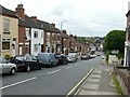
Brookhill Street, Stapleford
Looking down towards Derby Road.
Image: © Alan Murray-Rust
Taken: 12 Jun 2018
0.10 miles
5
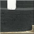
Bench mark, 53 Brookhill Street, Stapleford
See http://www.geograph.org.uk/photo/5808703 for location.
Image: © Alan Murray-Rust
Taken: 12 Jun 2018
0.10 miles
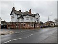
6
The Midland on Derby Road, Stapleford
http://www.geograph.org.uk/photo/5040811
Image: © Ian S
Taken: 16 Jul 2016
0.11 miles
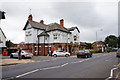
7
The Midland, Stapleford
Former Midland Hotel
Image: © Andrew Abbott
Taken: 28 Dec 2019
0.12 miles
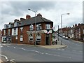
8
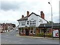
The Midland, Derby Road, Stapleford
An example of restrained Art Nouveau architecture.
Image: © Alan Murray-Rust
Taken: 12 Jun 2018
0.12 miles
9
The Midland on Derby Road, Stapleford
http://www.geograph.org.uk/photo/5040810
Image: © Ian S
Taken: 16 Jul 2016
0.12 miles
10
West End Club, Derby Road, Stapleford
Built as a bank but it has been the West End Club since at least the 1950s. There is a bench mark http://www.geograph.org.uk/photo/5808696 to the left of the doorway.
Image: © Alan Murray-Rust
Taken: 12 Jun 2018
0.12 miles