IMAGES TAKEN NEAR TO
Broad Oak Drive, NOTTINGHAM, NG9 7AX
Introduction
This page details the photographs taken nearby to Broad Oak Drive, NG9 7AX by members of the Geograph project.
The Geograph project started in 2005 with the aim of publishing, organising and preserving representative images for every square kilometre of Great Britain, Ireland and the Isle of Man.

There are currently over 7.5m images from over14,400 individuals and you can help contribute to the project by visiting https://www.geograph.org.uk
Image Map
Images are licensed for reuse under creativecommons.org/licenses/by-sa/2.0
Notes
- Clicking on the map will re-center to the selected point.
- The higher the marker number, the further away the image location is from the centre of the postcode.
Image Listing (39 Images Found)
Images are licensed for reuse under creativecommons.org/licenses/by-sa/2.0
Image
Details
Distance
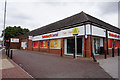
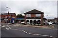
2
Sainsbury's Local, Stapleford
Smaller versions of the large supermarkets are proliferating in many towns and suburbs, typically staying open 16 hours per day, 7 days per week. This is a Sainsbury's Local on Derby Road, Stapleford.
Image: © Stephen McKay
Taken: 1 Oct 2011
0.07 miles
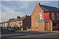
4
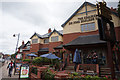
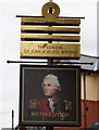
The Admiral Sir John Borlase Warren
A Wetherspoons public house on Derby Road, Stapleford. http://www.geograph.org.uk/photo/5041167 http://www.geograph.org.uk/photo/5041169
Image: © Ian S
Taken: 16 Jul 2016
0.08 miles
5
Cinnamon Restaurant
On Derby Road, Stapleford.
Image: © Ian S
Taken: 16 Jul 2016
0.08 miles
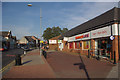
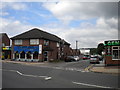
6
Derby Road, Stapleford
Wetherspoons are building a new pub here on the corner of Derby Road and Alexandra Street on the site of the former health centre.
Image: © Stephen McKay
Taken: 1 Oct 2011
0.09 miles
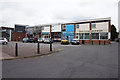
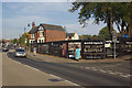
7
Park Street, Stapleford
Seen from Derby Road with a decorating supplies shop on the corner.
Image: © Stephen McKay
Taken: 1 Oct 2011
0.09 miles
8

The Admiral Sir John Borlase Warren
A Wetherspoons public house on Derby Road, Stapleford. http://www.geograph.org.uk/photo/5041162 http://www.geograph.org.uk/photo/5041169
Image: © Ian S
Taken: 16 Jul 2016
0.09 miles
9
Sandiacre Road, Stapleford
Although this road approximately faces Sandiacre, it ends abruptly long before it gets there. Derby Road, from whose junction Sandiacre Road is seen, is the actual road between the two towns.
Image: © Richard Vince
Taken: 7 Jul 2012
0.09 miles
10
The Admiral Sir John Borlase Warren
A Wetherspoons public house on Derby Road, Stapleford. http://www.geograph.org.uk/photo/5041167 http://www.geograph.org.uk/photo/5041162
Image: © Ian S
Taken: 16 Jul 2016
0.09 miles