IMAGES TAKEN NEAR TO
Lonsdale Drive, NOTTINGHAM, NG9 6LS
Introduction
This page details the photographs taken nearby to Lonsdale Drive, NG9 6LS by members of the Geograph project.
The Geograph project started in 2005 with the aim of publishing, organising and preserving representative images for every square kilometre of Great Britain, Ireland and the Isle of Man.

There are currently over 7.5m images from over14,400 individuals and you can help contribute to the project by visiting https://www.geograph.org.uk
Image Map
Images are licensed for reuse under creativecommons.org/licenses/by-sa/2.0
Notes
- Clicking on the map will re-center to the selected point.
- The higher the marker number, the further away the image location is from the centre of the postcode.
Image Listing (116 Images Found)
Images are licensed for reuse under creativecommons.org/licenses/by-sa/2.0
Image
Details
Distance
1

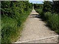
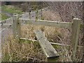
Power line across Toton Fields
With a major source of power - Ratcliffe-0n-Soar power station - in view.
Image: © David Lally
Taken: 19 Jan 2021
0.04 miles

4
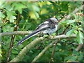
Recently fledged Long-tailed Tit.
Above Toton Sidings.
Image: © Andy Jamieson
Taken: 31 May 2009
0.06 miles
7
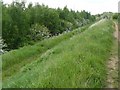
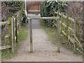
Path by Toton sidings looking at the Silver Birch wood
Image: © Andy Jamieson
Taken: 10 May 2009
0.07 miles
9
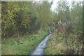
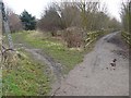
Track in Toton Fields Nature reserve
The description from the Broxtowe Borough web site:
"This reserve takes in parts of the Manor Farm and Banks Road Open Spaces, with the main access being via the Greenwood Community Centre off Banks Road. The site lies alongside the River Erewash with associated wetland species, wet grassland and young woodland."
http://www.broxtowe.gov.uk/index.aspx?articleid=4385
Image: © David Lally
Taken: 27 Dec 2013
0.08 miles