IMAGES TAKEN NEAR TO
Aston Green, NOTTINGHAM, NG9 6LG
Introduction
This page details the photographs taken nearby to Aston Green, NG9 6LG by members of the Geograph project.
The Geograph project started in 2005 with the aim of publishing, organising and preserving representative images for every square kilometre of Great Britain, Ireland and the Isle of Man.

There are currently over 7.5m images from over14,400 individuals and you can help contribute to the project by visiting https://www.geograph.org.uk
Image Map
Images are licensed for reuse under creativecommons.org/licenses/by-sa/2.0
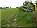
Notes
- Clicking on the map will re-center to the selected point.
- The higher the marker number, the further away the image location is from the centre of the postcode.
Image Listing (58 Images Found)
Images are licensed for reuse under creativecommons.org/licenses/by-sa/2.0
Image
Details
Distance
2
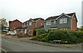
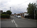
Bridgnorth Way, Toton
Modern housing on the edge of town.
Image: © Mary and Angus Hogg
Taken: 18 Oct 2017
0.07 miles
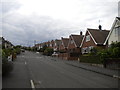
4
Seaburn Road, Toton
Seen from the junction with Cleveleys Road.
Image: © Richard Vince
Taken: 17 Aug 2015
0.10 miles
7
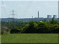
Toton,view of the Power station at Ratcliffe
Image: © Andy Jamieson
Taken: 31 May 2009
0.10 miles
8
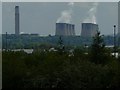
From Path at Toton to the Railway sidings and Long Eaton
Ratcliffe on Soar power station
Image: © Andy Jamieson
Taken: 10 May 2009
0.10 miles
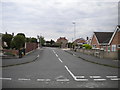
9
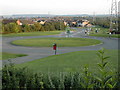
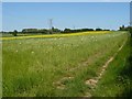
Roundabout and open space at the end of Banks Lane, Toton
This view is taken from the children's playground at approximately SK 490 351 looking back down Banks Lane to the south. The area on the right is used as a play area by local children.
Image: © Peter Shone
Taken: 22 Sep 2005
0.10 miles