IMAGES TAKEN NEAR TO
Long Lane, NOTTINGHAM, NG9 6BQ
Introduction
This page details the photographs taken nearby to Long Lane, NG9 6BQ by members of the Geograph project.
The Geograph project started in 2005 with the aim of publishing, organising and preserving representative images for every square kilometre of Great Britain, Ireland and the Isle of Man.

There are currently over 7.5m images from over14,400 individuals and you can help contribute to the project by visiting https://www.geograph.org.uk
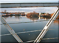
Image Map
Images are licensed for reuse under creativecommons.org/licenses/by-sa/2.0
Notes
- Clicking on the map will re-center to the selected point.
- The higher the marker number, the further away the image location is from the centre of the postcode.
Image Listing (64 Images Found)
Images are licensed for reuse under creativecommons.org/licenses/by-sa/2.0
Image
Details
Distance
1
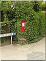
Manor Avenue postbox
GR wallbox in a brick pillar. There is a benchmark hidden under the ivy below the bottom right hand corner of the box.
Image: © Alan Murray-Rust
Taken: 26 Apr 2022
0.04 miles
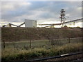
2
Cemex Concrete Plant, Attenborough
This concrete plant is a little out of place in residential Attenborough, but it is here to exploit the river sand by the side of the Trent.
Image: © Oxymoron
Taken: 20 Aug 2008
0.05 miles
3
Gravel Extraction Workings Near Long Eaton
Image: © Roy Hughes
Taken: 1 Dec 2012
0.07 miles
4
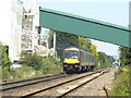
Train to Nottingham
Passing the aggregates plant at Attenborough. Seen from the footpath crossing at the end of Allendale Avenue.
Image: © Alan Murray-Rust
Taken: 1 Jun 2009
0.07 miles
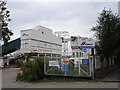
5
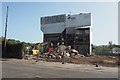
Cemex sorting plant is revealed
The plant which sorted the sand and gravel extract from the north bank of the Trent between here and near Long Eaton closed with the end of extraction a few years ago. After laying empty for this time it is now being demolished.
Image: © David Lally
Taken: 17 Sep 2020
0.08 miles
6
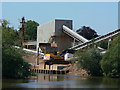
Unloading quay
Attenborough Quarry is possibly unique in still retaining barge traffic to bring the raw aggregates from the quarry site to the processing plant. This clearly made sense when the extraction grounds were relatively close, and the method has been retained even though the loading point is over 4 kilometres distant. This is the unloading quay near Attenborough village.
Image: © Alan Murray-Rust
Taken: 1 Jun 2009
0.08 miles
7
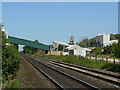
Railway and aggregates plant
Seen from the footpath crossing at the end of Allendale Avenue.
Image: © Alan Murray-Rust
Taken: 1 Jun 2009
0.09 miles
8
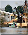
Unloading a barge
At the Cemex http://www.geograph.org.uk/photo/929166 works in Attenborough. The barge and tug combination (see:Image and Image]) will have brought its load of sand and gravel from the current excavations which are taking place well to the south west near Long Eaton: Image
The scene shortly after: Image
Image: © David Lally
Taken: 17 Mar 2011
0.09 miles
10

Barge unloaded
Following on from Image, the first barge is now unloaded and starts to move-off. While another combination with a full barge awaits.
Shortly after: Image
Notice the difference in the displacement of the two barges!
Image: © David Lally
Taken: 17 Mar 2011
0.10 miles