IMAGES TAKEN NEAR TO
The Twitchell, NOTTINGHAM, NG9 5BD
Introduction
This page details the photographs taken nearby to The Twitchell, NG9 5BD by members of the Geograph project.
The Geograph project started in 2005 with the aim of publishing, organising and preserving representative images for every square kilometre of Great Britain, Ireland and the Isle of Man.

There are currently over 7.5m images from over14,400 individuals and you can help contribute to the project by visiting https://www.geograph.org.uk
Image Map
Images are licensed for reuse under creativecommons.org/licenses/by-sa/2.0
Notes
- Clicking on the map will re-center to the selected point.
- The higher the marker number, the further away the image location is from the centre of the postcode.
Image Listing (170 Images Found)
Images are licensed for reuse under creativecommons.org/licenses/by-sa/2.0
Image
Details
Distance
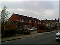
1
Rosedene of 1912
At 6 The Twitchell, Chilwell.
Image: © Andrew Abbott
Taken: 11 Apr 2020
0.01 miles
2
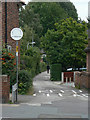
The Twitchell
Twitchell is a local name for a narrow, normally enclosed, lane.
I had understood it to be relatively local, but a bit of research shows that it is also used in the South Midlands round Bedford. Further north this would probably be called a snicket.
Image: © Alan Murray-Rust
Taken: 6 Sep 2009
0.01 miles
4
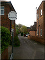
The Twitchell, off Chilwell High Road
A Twitchel is the local dialect word for an alleyway. Here one example is actually named as such.
Image: © David Lally
Taken: 23 Apr 2009
0.02 miles
5
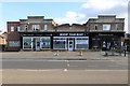
165-169 High Road, Chilwell
Three shops from the 1930s.
Image: © Andrew Abbott
Taken: 24 May 2020
0.03 miles
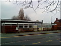
6
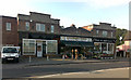
Three Shops from the 1930s
Judging by the mildly art-deco style.
These are on Chilwell High Road.
Image: © David Lally
Taken: 11 Aug 2009
0.03 miles
7
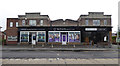
Shops from the 1930s
On High Road, Chilwell. Recently housed a florist and butchers, but now mostly a dental practice Image
Image: © David Lally
Taken: 12 May 2017
0.04 miles
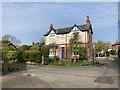
8
Buildings on High Road
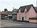
The pink house probably dates from the mid-19th century, the row of shops beyond from the 1930s. All are within the Chilwell Conservation Area.
Image: © Alan Murray-Rust
Taken: 6 Sep 2009
0.04 miles