IMAGES TAKEN NEAR TO
Cedar Road, NOTTINGHAM, NG9 4DB
Introduction
This page details the photographs taken nearby to Cedar Road, NG9 4DB by members of the Geograph project.
The Geograph project started in 2005 with the aim of publishing, organising and preserving representative images for every square kilometre of Great Britain, Ireland and the Isle of Man.

There are currently over 7.5m images from over14,400 individuals and you can help contribute to the project by visiting https://www.geograph.org.uk
Image Map
Images are licensed for reuse under creativecommons.org/licenses/by-sa/2.0
Notes
- Clicking on the map will re-center to the selected point.
- The higher the marker number, the further away the image location is from the centre of the postcode.
Image Listing (468 Images Found)
Images are licensed for reuse under creativecommons.org/licenses/by-sa/2.0
Image
Details
Distance
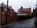
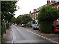
1
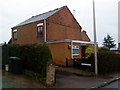
Junction of Cedar Road and Grove Avenue, Beeston
House at the junction of Cedar Road and Grove Avenue, Beeston
Image: © Andrew Abbott
Taken: 24 Mar 2010
0.03 miles
3
34 Park Road, Chilwell
In the Cottage Grove Conservation Area.
Image: © Andrew Abbott
Taken: 6 Apr 2020
0.04 miles
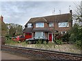
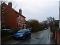
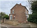
4
Park Road, Chilwell
The narrow roads in this area were developed from around 1885 before any thought for the needs of motorised traffic.
Image: © Alan Murray-Rust
Taken: 22 Dec 2013
0.04 miles
5
Grove Avenue, Beeston
Grove Avenue, Beeston near the junction with Dale Lane.
Image: © Andrew Abbott
Taken: 24 Mar 2010
0.04 miles
6
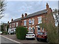
40 and 42 Park Road, Chilwell
Jubilee Villas of 1887. In the Cottage Grove Conservation Area.
Image: © Andrew Abbott
Taken: 6 Apr 2020
0.04 miles
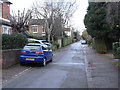
8
Park Road, Beeston
View of Park Road in Beeston looking south. This street is part of a conservation area.
Image: © Andrew Abbott
Taken: 24 Mar 2010
0.05 miles
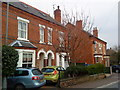
9
Park Road, Beeston
This is representative of a small area of very narrow, heavily tree-lined residential roads to the west of Beeston town centre, probably comprising a late Victorian expansion to the town (the row of villas to the right of the photo bear a plaque dated 1887).
Image: © Oxymoron
Taken: 5 Aug 2008
0.05 miles
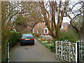
10
48 Park Road, Chilwell
In the Cottage Grove Conservation Area.
Image: © Andrew Abbott
Taken: 6 Apr 2020
0.05 miles