IMAGES TAKEN NEAR TO
Harvey Croft, NOTTINGHAM, NG9 3QW
Introduction
This page details the photographs taken nearby to Harvey Croft, NG9 3QW by members of the Geograph project.
The Geograph project started in 2005 with the aim of publishing, organising and preserving representative images for every square kilometre of Great Britain, Ireland and the Isle of Man.

There are currently over 7.5m images from over14,400 individuals and you can help contribute to the project by visiting https://www.geograph.org.uk
Image Map
Images are licensed for reuse under creativecommons.org/licenses/by-sa/2.0
Notes
- Clicking on the map will re-center to the selected point.
- The higher the marker number, the further away the image location is from the centre of the postcode.
Image Listing (55 Images Found)
Images are licensed for reuse under creativecommons.org/licenses/by-sa/2.0
Image
Details
Distance
1
Trowell NG9, Notts
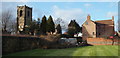
South-easterly aspects of St Helen's Church and Wilnefield House (the greatly extended, one-time village rectory or vicarage) as seen from a field belonging to the present owner of Wilnefield House. The word Wilne is thought to be related to the word willow. Harvey Grove, a residential cul-de-sac beyond a boundary fence that is situated behind the photographer was named using the surname of the present owner's father.
Image: © David Hallam-Jones
Taken: 31 Jan 2013
0.04 miles
2
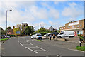
Trowell NG9, Notts
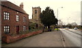
With Wollaton a 20 minute drive away behind the photographer, this is a view of Nottingham Road (the A609) as it follows a right-angled turn and heads towards Ilkeston. The white car at the midpoint of the junction is about to join the A6007, behind St Helen's Church. This is Stapleford Road that ultimately leads to the Bramcote area of Nottingham. Wilnefield House, the large brick built house on the left dates from 1650 and once functioned as the rectory or vicarage for St Helen's Church. According to its owner it has been greatly extended over the years.
Image: © David Hallam-Jones
Taken: 31 Jan 2013
0.04 miles
3
4 Nottingham Road, Trowell
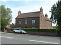
Former farmhouse, late 18th century, Listed Grade II.
Image: © Alan Murray-Rust
Taken: 9 Aug 2021
0.05 miles
6
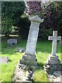
In Memory of John Whyte, Colliery Manager
The dedication of this memorial in St Helen's churchyard by the directors and officials of the Cossall and Trowell Moor collieries reminds one that this used to be a coal mining district - all gone now, of course.
Image: © Oxymoron
Taken: 27 Sep 2008
0.05 miles
7
Trowell: Nottingham Road
Looking towards the parish church on a fine October morning.
Image: © John Sutton
Taken: 14 Oct 2017
0.05 miles
8
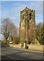
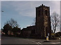
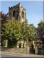
Trowell Church tower
This stately tower stands up well above the village. Dedicated to St Helen, the church dates from the 13th to 15th centuries but shows plenty of evidence of the typical Victorian restoration.
Image: © Alan Murray-Rust
Taken: 11 Nov 2007
0.05 miles
9
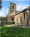
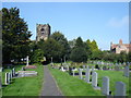
In Trowell churchyard
The east end of the churchyard is hemmed in by houses and there is a thick holly hedge to lean against when taking photographs like this. St Helen's has thirteenth- and fourteenth-century elements and was restored in 1890 by Hodgson Fowler.
Image: © John Sutton
Taken: 14 Oct 2017
0.05 miles