IMAGES TAKEN NEAR TO
Ellesmere Drive, NOTTINGHAM, NG9 3PH
Introduction
This page details the photographs taken nearby to Ellesmere Drive, NG9 3PH by members of the Geograph project.
The Geograph project started in 2005 with the aim of publishing, organising and preserving representative images for every square kilometre of Great Britain, Ireland and the Isle of Man.

There are currently over 7.5m images from over14,400 individuals and you can help contribute to the project by visiting https://www.geograph.org.uk
Image Map
Images are licensed for reuse under creativecommons.org/licenses/by-sa/2.0
Notes
- Clicking on the map will re-center to the selected point.
- The higher the marker number, the further away the image location is from the centre of the postcode.
Image Listing (32 Images Found)
Images are licensed for reuse under creativecommons.org/licenses/by-sa/2.0
Image
Details
Distance
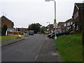
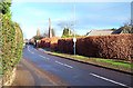
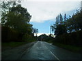
2
Cossall Road
Cossall Road connects Trowell to Cossall and starts as a very straight road but soon becomes very twisty.
Image: © Malcolm Neal
Taken: 18 Nov 2021
0.06 miles
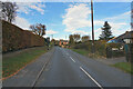
4
The road from Trowell to Cossall, looking south
Image: © Alan Murray-Rust
Taken: 11 Nov 2007
0.08 miles
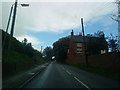
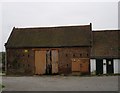
5
Cossall Ln, Trowell
A minor but at times, very busy road leading from Trowell to Cossall.
Image: © Garth Newton
Taken: 7 Jan 2001
0.09 miles
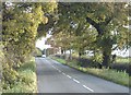
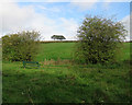
7
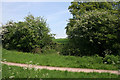
A glimpse of the hill by Grange Wood
As you walk along the Nottingham Canal Nature Reserve you get glimpses of the rising ground to the east through the hedgerow trees.
Image: © Kate Jewell
Taken: 12 May 2008
0.12 miles
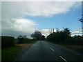
10
Trowell: fields by the former canal
The Nottingham Canal was abandoned eighty years ago and this stretch is now a nature reserve. The ridges and furrows of the mediaeval fields show clearly on the slopes north of this filled-in section of the canal.
Image: © John Sutton
Taken: 14 Oct 2017
0.15 miles