IMAGES TAKEN NEAR TO
Linford Court, NOTTINGHAM, NG9 3ND
Introduction
This page details the photographs taken nearby to Linford Court, NG9 3ND by members of the Geograph project.
The Geograph project started in 2005 with the aim of publishing, organising and preserving representative images for every square kilometre of Great Britain, Ireland and the Isle of Man.

There are currently over 7.5m images from over14,400 individuals and you can help contribute to the project by visiting https://www.geograph.org.uk
Image Map
Images are licensed for reuse under creativecommons.org/licenses/by-sa/2.0
Notes
- Clicking on the map will re-center to the selected point.
- The higher the marker number, the further away the image location is from the centre of the postcode.
Image Listing (47 Images Found)
Images are licensed for reuse under creativecommons.org/licenses/by-sa/2.0
Image
Details
Distance
1
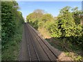
Railway in Wollaton
On the Trowell Junction to Radford Junction line between Ilkeston and Nottingham.
Image: © Andrew Abbott
Taken: 24 Apr 2020
0.05 miles


4
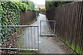
Twitchell
Between Teesbrook Drive and Sharnford Way.
Image: © David Lally
Taken: 16 Feb 2010
0.06 miles
5
Towpath of the Nottingham Canal
On the Trowell Junction to Radford Junction line. The bridge took the railway over the Nottingham Canal.
Image: © Andrew Abbott
Taken: 26 Apr 2020
0.06 miles
6
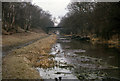
Nottingham Canal from Moor Lane Bridge
In March 1963, the canal still held water here, although it was now in a very sorry state; a sunken barge reposes near the bank although some attempt has been made to tidy up the area with recent tree and shrub trimming on the right (north) bank. The archetypal March grey day does nothing to lift the scene of total dereliction. All traffic ceased here in about 1936.
Image: © Richard Bird
Taken: 10 Mar 1963
0.06 miles
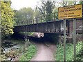
7
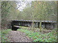
Railway bridge over the former Nottingham Canal
As can be seen, the canal has been heavily filled in at this point. The footpath is part of the canal towpath walk but is not shown on the OS maps as a right of way.
In 1963, the canal at this location looked like this http://www.geograph.org.uk/photo/3837670
Image: © Alan Murray-Rust
Taken: 25 Nov 2007
0.06 miles
8

No Tipping sign
Put up by Broxtowe Borough Council, but I was stood in The City of Nottingham to take the picture!
Image: © David Lally
Taken: 16 Feb 2010
0.07 miles
9
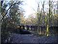
Bridge over former Nottingham Canal, Wollaton
This former section of the Nottingham Canal, on the western edge of Wollaton, is now a local nature reserve. At this point, the canal cutting has been filled in, but the formation returns to its original level so that the footpath can pass beneath the railway bridge. Image is a view of the same section of the canal, but looking the opposite way and taken before the section in the foreground here was filled in. The bridge carries the railway line between Radford and Trowell Junctions, used by trains between Nottingham and Sheffield.
Image: © Richard Vince
Taken: 13 Dec 2014
0.07 miles
10
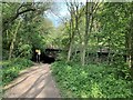
Railway bridge
On the Trowell Junction to Radford Junction line. The bridge took the railway over the Nottingham Canal.
Image: © Andrew Abbott
Taken: 26 Apr 2020
0.07 miles