IMAGES TAKEN NEAR TO
St. Michaels Square, NOTTINGHAM, NG9 3HG
Introduction
This page details the photographs taken nearby to St. Michaels Square, NG9 3HG by members of the Geograph project.
The Geograph project started in 2005 with the aim of publishing, organising and preserving representative images for every square kilometre of Great Britain, Ireland and the Isle of Man.

There are currently over 7.5m images from over14,400 individuals and you can help contribute to the project by visiting https://www.geograph.org.uk
Image Map
Images are licensed for reuse under creativecommons.org/licenses/by-sa/2.0
Notes
- Clicking on the map will re-center to the selected point.
- The higher the marker number, the further away the image location is from the centre of the postcode.
Image Listing (133 Images Found)
Images are licensed for reuse under creativecommons.org/licenses/by-sa/2.0
Image
Details
Distance
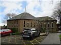
1
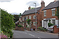
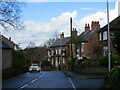
Town Street, Bramcote
Looking down Town Street in the old village area of Bramcote. The pub is the White Lion, known to locals as Top House.
Image: © Stephen McKay
Taken: 1 Jul 2007
0.05 miles
2
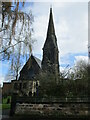
Church of St. Michael and All Angels, Bramcote
Built 1861 https://historicengland.org.uk/listing/the-list/list-entry/1247920?section=official-list-entry Designed by John Johnson https://en.wikipedia.org/wiki/John_Johnson_(architect,_born_1807)
Image: © Jonathan Thacker
Taken: 13 Apr 2022
0.05 miles
3
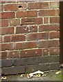
Bench mark, The White Lion, Bramcote
On an outbuilding at the rear of the pub.
Image: © Alan Murray-Rust
Taken: 17 Oct 2016
0.06 miles
4
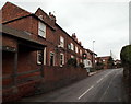
Bramcote NG9, Notts.
An unusual covered stretch of pavement outside the White Lion pub on Town Street. "Top House", as the pub is sometimes called - because of it being the highest pub in the locality - is a Grade II-listed building that originated in the mid-18th century. Over the brow of the hill lies a junction at the side of which the tower of the former 14th parish church (a.k.a. The Sunken Church) can still be seen in its former graveyard.
Image: © David Hallam-Jones
Taken: 21 Mar 2013
0.06 miles
6
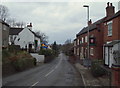
Bramcote NG9, Notts.
Town Street runs up and down hill here. In less than a minute, drivers can access the busy A52, A6007 and B5010 roundabout at the foot of this hill, whilst close by, behind the photographer, lie the remains of the former 14th century parish church and St John's Theological College. The Grade II-listed White Lion pub on the right has mid 18th century origins.
Image: © David Hallam-Jones
Taken: 21 Mar 2013
0.06 miles
7
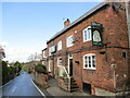
The White Lion, Bramcote
Dates from the mid eighteenth century with later additions https://historicengland.org.uk/listing/the-list/list-entry/1247962?section=official-list-entry
Image: © Jonathan Thacker
Taken: 13 Apr 2022
0.06 miles
8
Bramcote NG9, Notts.
Church Street - on the left - is seen here joining (or leaving) Town Street, the village's main thoroughfare. The White Lion ahead, c.1750, is sometimes referred to as "The Top House" because it is the highest pub in the surrounding area.
Image: © David Hallam-Jones
Taken: 21 Mar 2013
0.06 miles
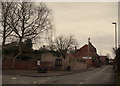
10
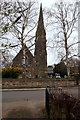
Bramcote NG9, Notts.
The Church of St Michael's and All Angels on Church Street is seen here from a driveway opposite.
Image: © David Hallam-Jones
Taken: 21 Mar 2013
0.07 miles