IMAGES TAKEN NEAR TO
Chapel Street, NOTTINGHAM, NG9 3HB
Introduction
This page details the photographs taken nearby to Chapel Street, NG9 3HB by members of the Geograph project.
The Geograph project started in 2005 with the aim of publishing, organising and preserving representative images for every square kilometre of Great Britain, Ireland and the Isle of Man.

There are currently over 7.5m images from over14,400 individuals and you can help contribute to the project by visiting https://www.geograph.org.uk
Image Map
Images are licensed for reuse under creativecommons.org/licenses/by-sa/2.0
Notes
- Clicking on the map will re-center to the selected point.
- The higher the marker number, the further away the image location is from the centre of the postcode.
Image Listing (121 Images Found)
Images are licensed for reuse under creativecommons.org/licenses/by-sa/2.0
Image
Details
Distance
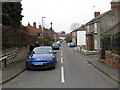
2
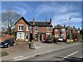
Town Street, Bramcote
From the junction with the A52
Image: © David Lally
Taken: 29 Jan 2008
0.02 miles
3
17 Town Street, Bramcote
End house in a terrace on Chapel Street
Image: © Andrew Abbott
Taken: 22 Mar 2020
0.02 miles
4
Chapel Street Bramcote
A quiet road close to the very busy A52 which links Nottingham and Derby. For several years the A52 has been renamed Brian Clough Way.
Image: © Malcolm Neal
Taken: 14 Jul 2018
0.03 miles
5
19-23 Town Street, Bramcote
A terrace of three houses.
Image: © Andrew Abbott
Taken: 22 Mar 2020
0.03 miles
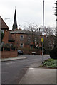
6
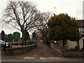
Bramcote NG9, Notts.
Broxtowe Borough Council have responsiblility for this park - King George's Field Recreation Ground - on Town Street. Its car park is sandwiched between the main entrance gates and the village's former junior and infants' school, now a privately-owned nursery.
Image: © David Hallam-Jones
Taken: 21 Mar 2013
0.03 miles
7
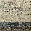
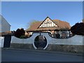
Bench mark, 37 Chapel Street, Bramcote
See http://www.geograph.org.uk/photo/5159323 for location.
Image: © Alan Murray-Rust
Taken: 17 Oct 2016
0.04 miles
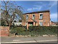
8
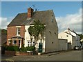
Bray Gottages, Chapel Street, Bramcote
There is a bench mark http://www.geograph.org.uk/photo/5159321 on the side wall of the corner house.
Image: © Alan Murray-Rust
Taken: 17 Oct 2016
0.04 miles
9
8 Church Street, Bramcote
A house within the Bramcote Conservation Area.
Image: © Andrew Abbott
Taken: 16 Apr 2020
0.04 miles
10
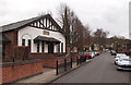
Bramcote NG9, Notts.
Bramcote Memorial Hall, midway along Church Street, bears a plaque relating its existence to World War I. The Parish Centre of St Michael and All Angels Church is out of sight, behind it, sandwiched between this hall and the church.
Image: © David Hallam-Jones
Taken: 21 Mar 2013
0.04 miles