IMAGES TAKEN NEAR TO
Eyam Close, NOTTINGHAM, NG9 3GQ
Introduction
This page details the photographs taken nearby to Eyam Close, NG9 3GQ by members of the Geograph project.
The Geograph project started in 2005 with the aim of publishing, organising and preserving representative images for every square kilometre of Great Britain, Ireland and the Isle of Man.

There are currently over 7.5m images from over14,400 individuals and you can help contribute to the project by visiting https://www.geograph.org.uk
Image Map
Images are licensed for reuse under creativecommons.org/licenses/by-sa/2.0
Notes
- Clicking on the map will re-center to the selected point.
- The higher the marker number, the further away the image location is from the centre of the postcode.
Image Listing (10 Images Found)
Images are licensed for reuse under creativecommons.org/licenses/by-sa/2.0
Image
Details
Distance
1
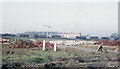
Housing development - Wollaton and Balloon Wood
This scene has changed beyond all recognition since this photograph was taken late in 1967. In the foreground development was under way extending the large area of private housing that appeared to the south of Wollaton Vale and north west of Bramcote Lane from the 1950s to the 1970s. Nowadays, of course, sites like this would be locked in securely behind yards of Heras fencing but no such precautions were deemed necessary then. Beyond that, and separated by a railway line, the flats at Balloon Wood were being built. The flats were intended to house people who had lost their homes as inner city slums were cleared but they were never successful, unpopular with residents and suffering from construction defects, and were demolished in 1984 to be replaced by an estate of conventional houses.
Image: © Stephen McKay
Taken: Unknown
0.12 miles
2
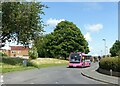
A pink suburban bus
Operating on Nottingham City Transport's Pink Line service 30, seen here on Grangewood Road. Bus 336 is an Optare Solo SR new in 2011.
Image: © Alan Murray-Rust
Taken: 9 Aug 2021
0.20 miles
3
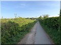
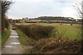
Track in Bramcote
Alongside the playing fields
Image: © Andrew Abbott
Taken: 24 Apr 2020
0.20 miles
4
Nottingham Canal Trail - Latimer Drive, Bramcote Moor
Recreating this 'First' for the square https://www.geograph.org.uk/photo/482946 . The Nottingham Canal Trail has been absorbed by the Broxtowe Country Trail at this point and is not separately waymarked.
The house has gained a new wing.
Image: © Alan Murray-Rust
Taken: 9 Aug 2021
0.21 miles
5
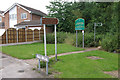
Nottingham Canal Trail - Latimer Drive, Bramcote Moor
The Nottingham Canal Trail starts here in this unassuming suburban location and then runs for over 7 miles along the long-disused Nottingham Canal through Trowell to Eastwood. It is designated as a local nature reserve.
Image: © Stephen McKay
Taken: 1 Jul 2007
0.22 miles
6
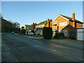
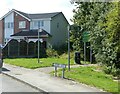
Deddington Lane, Bramcote
This end of the lane is part of a housing estate.
Image: © Stephen Craven
Taken: 19 Jan 2020
0.22 miles
7
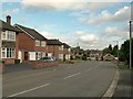
Deddington Lane
Archetypal post-war suburbia.
Image: © Alan Murray-Rust
Taken: 17 Oct 2016
0.23 miles
8
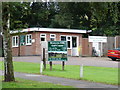
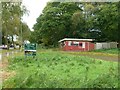
Bramcote Hills Golf Course Clubhouse
This is the clubhouse (effectively, the hut where you pay your fees) for the municipally-run nine-hole course at Bramcote Hills.
Image: © Oxymoron
Taken: 10 Aug 2008
0.24 miles
9
View toward Bramcote Hill over playing fields
With Bramcote Hills School next to the hill and a new pavilion not yet on the map.
Image: © David Lally
Taken: 16 Feb 2010
0.24 miles
10
Bramcote Hills Golf Course
Despite the sign, the course was closed several years earlier. At the time of writing, an application to build retirement housing on the site had been rejected as the local Council wished the area to remain a green space.
Image: © Alan Murray-Rust
Taken: 17 Oct 2016
0.25 miles